Picture-postcard Rhode Island scenery awaits at Tillinghast Pond trail
WEST GREENWICH – The loop trail around Tillinghast Pond is one of my favorite hikes. I’ve circled the tranquil pond several times in various seasons under a canopy of white pine, oak, ash, beech and maple trees that help form the largest coastal forest from Boston to Washington, D.C.
So when I was invited to explore a different trail in the 2,200-acre Tillinghast Pond Management Area, I jumped at the chance.
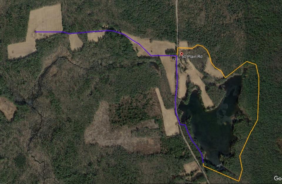
The group hike, organized by The Nature Conservancy, the nonprofit organization that owns and co-manages the preserve with the Rhode Island Department of Environmental Management and the Town of West Greenwich, began at a trailhead off Plain Road.
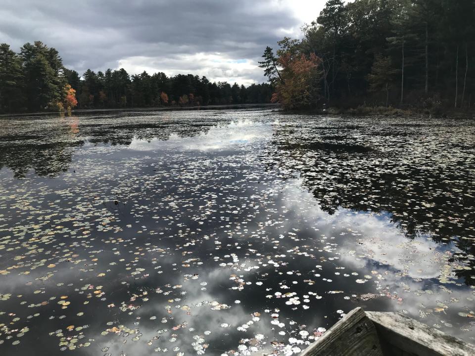
We set out heading northwest on a white-blazed, rooted footpath that runs on the banks of the pond on the right. After a short distance, the orange-blazed Coney Brook Trail opens on the left and loops through the western end of the preserve, but we stayed on the white-marked trail. Openings in the trees offered great views of the 41-acre pond.
The trail exits the woods and follows Plain Road for a short distance, crossing an outlet from the pond that forms Coney Brook. An old stone slab bridge built over the brook can be seen just off the road to the right.
We walked up the road on a gentle slope flanked by stone walls, with private property on the right and a huge pasture on the left where a swarm of starlings darted across the sky.
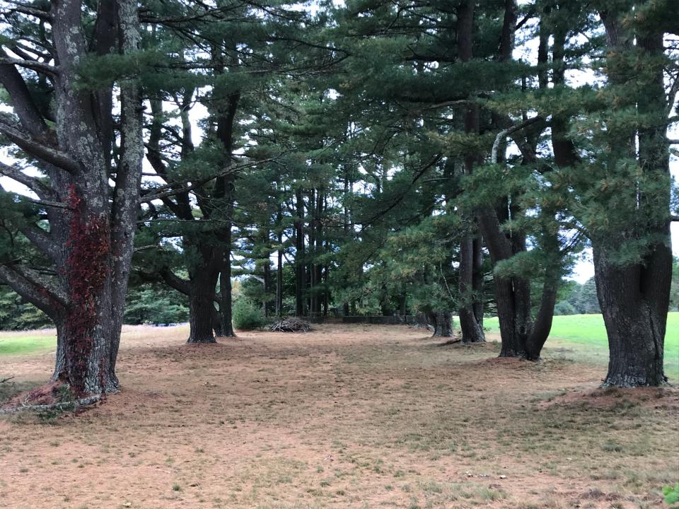
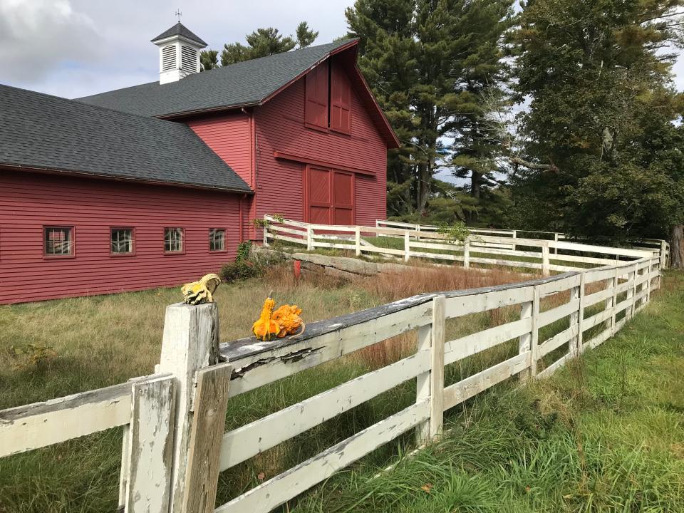
After reaching a white fence in front of a red barn, we turned left at a gate and followed an unblazed, dirt farm road called the Packer Trail. On the right, two, wide, parallel columns of tall pine trees form a quiet, needle-covered corridor to the Waite-Tillinghast cemetery.
The Tillinghasts arrived in Providence from England in 1643. Later, some family members moved to West Greenwich, where they farmed and cut and sold wood in the 1800s and early 1900s, according to research done by Tim Mooney, a co-leader of our group and the marketing and communications manager for the Rhode Island chapter of The Nature Conservancy.
Daniel Tillinghast (1815-1906) was perhaps the most prominent family member and served as town moderator in West Greenwich for 18 years.
Over the years, the Tillinghasts combined a number of adjacent parcels to expand their farmland. They owned the property until 1935, when it was sold to Robert L. Knight and his brother, Benjamin, who became “gentlemen farmers.” Their grandfather, also Robert L. Knight, founded Fruit of the Loom. Later, the land was sold to Edward McAlpine, whose descendants transferred the land to The Nature Conservancy in 2007.
Historic cemeteries along the trail
I entered the historic cemetery through an iron gate and noted that the graveyard was ringed with large stone block walls topped with an iron railing, which was often a sign of wealthy landowners. Daniel Tillinghast’s grave is marked with a large stone. His wife, Halma, the daughter of Silas Waite, another farmer, is nearby. I also spotted an American flag on the grave of Henry Tillinghast (1835-1909) and three small, unmarked stones for infants, two of which were dated 1831 and the other 1841.
When we returned to the Packer Trail, our group walked between several large fields where tenant farmers cut and store hay in white, plastic-wrapped bundles.
After a short descent, the trail passes a wooden structure on the left called Sally House, named for Sally Bennett, a relative of Stephen Bennett (1777-1849), who farmed the land. Behind the house are several dilapidated structures, including a shed and a garage. Across the road are stone walls and the remains of old wells.
Walking RI: These 10 Rhode Island trails should be on your bucket list
Continuing on the Packer Trail, we spotted the Stephen Bennett cemetery, almost hidden under pines on a hillside on the right. Most of the headstones were covered by brush and shrubs, but I found an iron gate between two stone pillars at the back of the cemetery.
After some inspection, we followed the raised farm road over some lowlands and passed two unusual sets of high, curved bridges built over streams that run to Coney Brook, which flows south to merge with water flowing out of Wickaboxet Pond to form Kelley Brook and eventually runs into the Wood River.
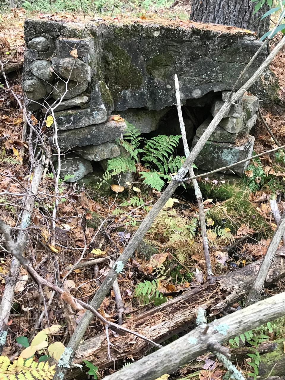
The bridges were built of round stones and later reinforced with concrete. When we brushed leaves from the top of the walls, we discovered that one was engraved with “L.A.” and another with “Mason” and dated 1911. Mason and Lloyd Tillinghast were sons of Daniel Tillinghast.
The road took us slightly uphill to a 25-acre pasture ringed with trees. On a hillock in the middle of the field is the small Ladd graveyard with about a dozen fieldstones. One marble stone with a curved top is engraved for a farmer named Daniel Ladd (1783-1862).
When we stopped for a break, Mooney told the story of a huge, granite boulder that had been excavated from the field and moved west to the edge of the management area to mark the start of the Shepard Trail off Hazard Road.
Picture-postcard Rhode Island scenery
At the far side of the field, the path continued into the woods, but we decided to stop and retrace our steps and headed back east on the Packer Trail. As we walked, we saw the red barn we had passed earlier rise above the hayfields on a hillside to create a classic Rhode Island scene. We also spotted a weather vane on top of a cupola and an adjacent silo. The barn and 10 surrounding acres, which The Nature Conservancy bought in 2019 with open-space funds from the DEM, is a roosting site for bats.
Back at the gate on Plain Road, it’s possible to cross the fields and walk east to get to the white-blazed trail around the pond, but to avoid private property, I suggest walking back down the road and picking up the trail that opens on the left, just before the stone slab bridge.
The path winds around the pond to a pine needle-covered peninsula. On earlier hikes, I'd lingered on a trail bench in a shady spot there and surveyed the kayakers and canoeists paddling around the pond. In late fall, though, all is quiet.
The path ran across the top of an earthen ridge, ducked into the trees, crossed a wooden bridge over a stream and then continued around the pond. There’s a short path on the right to Howard’s Rest, named for Howard White Murre, a humanitarian, naturalist and donor to conservation causes.
Walking RI: You've fished at Frosty Hollow Pond in spring. Discover how much fun it can be in fall.
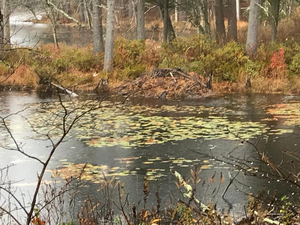
Signs of beaver activity at the edge of a cove
Farther along the trail, we came to another side spur that led to a wooden observation deck with a great view of the lily pad-covered pond. I scanned the wild, natural shoreline and spotted several duck boxes.
We took a short break and then continued on the trail as it rose and fell over ridges, passed some erratics and then dropped down to a line of bog bridges over wetlands at the northern tip of the pond. The trail then climbed a hillside and headed south. We followed the banks and passed a junction to the yellow-blazed Flintlock Loop, which runs east into the Wickaboxet Management Area.
We took a side spur and had a good look at two beaver lodges built at the edge of a cove. The path led to a bench on the banks of the pond. The quiet spot is named Phebe’s Grove, for Phebe Shepard, the wife of John Shepard of the department store family and the daughter of Edward McAlpine, once the property’s owner.
When McAlpine died in 1975, the land known as Glen Avon Farm passed to Phebe. After she died, her descendants honored her wishes to donate some land and sell other parcels to The Nature Conservancy. A sign at the grove reads that Phebe “fiercely protected” the land, pond, wildlife and forest in the preserve.
We walked back to the white-blazed trail and followed it along the east edge of the pond to a junction. We went right on a flat path that wound through thick, white pines and crossed stone walls before returning to where we'd started.
In all, we walked about 5 miles for about 2½ hours.
The rich history of the Tillinghasts and the other families who owned the farmland for hundreds of years is important to remember. But, it’s equally important to acknowledge the preservation of the land, pond, fields, watershed and woodlands that make up part of a 45,000-acre, unfragmented forest that stretches across the Rhode Island-Connecticut border.
All that makes Tillinghast a special, unique place.
If you go…
Access: Off Route 102 north, turn onto Plain Meetinghouse Road and drive for 3.5 miles. Turn right on Plain Road and drive a half mile to the trailhead on the right.
Parking: Available for 24 cars.
Dogs: Allowed but must be leashed.
Difficulty: Mostly easy, with some moderate hills and ridges.
Distance: 5 miles
GPS Coordinates: 41.64554, -71.75689
'Walking Rhode Island' book signing
John Kostrzewa’s new book, “Walking Rhode Island: 40 Hikes for Nature and History Lovers with Pictures, GPS Coordinates and Trail Maps,” is available at local booksellers and from Amazon.com. He’ll sell and sign books at the Rhode Island Authors Expo on Saturday, Dec. 2, from 10 a.m. to 4 p.m. at the Crowne Plaza Ballroom in Warwick.
John Kostrzewa’s column runs every other week in the Rhode Islander section of the Providence Sunday Journal. He welcomes email at johnekostrzewa@gmail.com.
This article originally appeared on The Providence Journal: Tillinghast Pond trail: Stunning RI scenery and historical cemeteries

