Explore the ruins of old Rhode Island farms on a winter walk along the Foster Loop
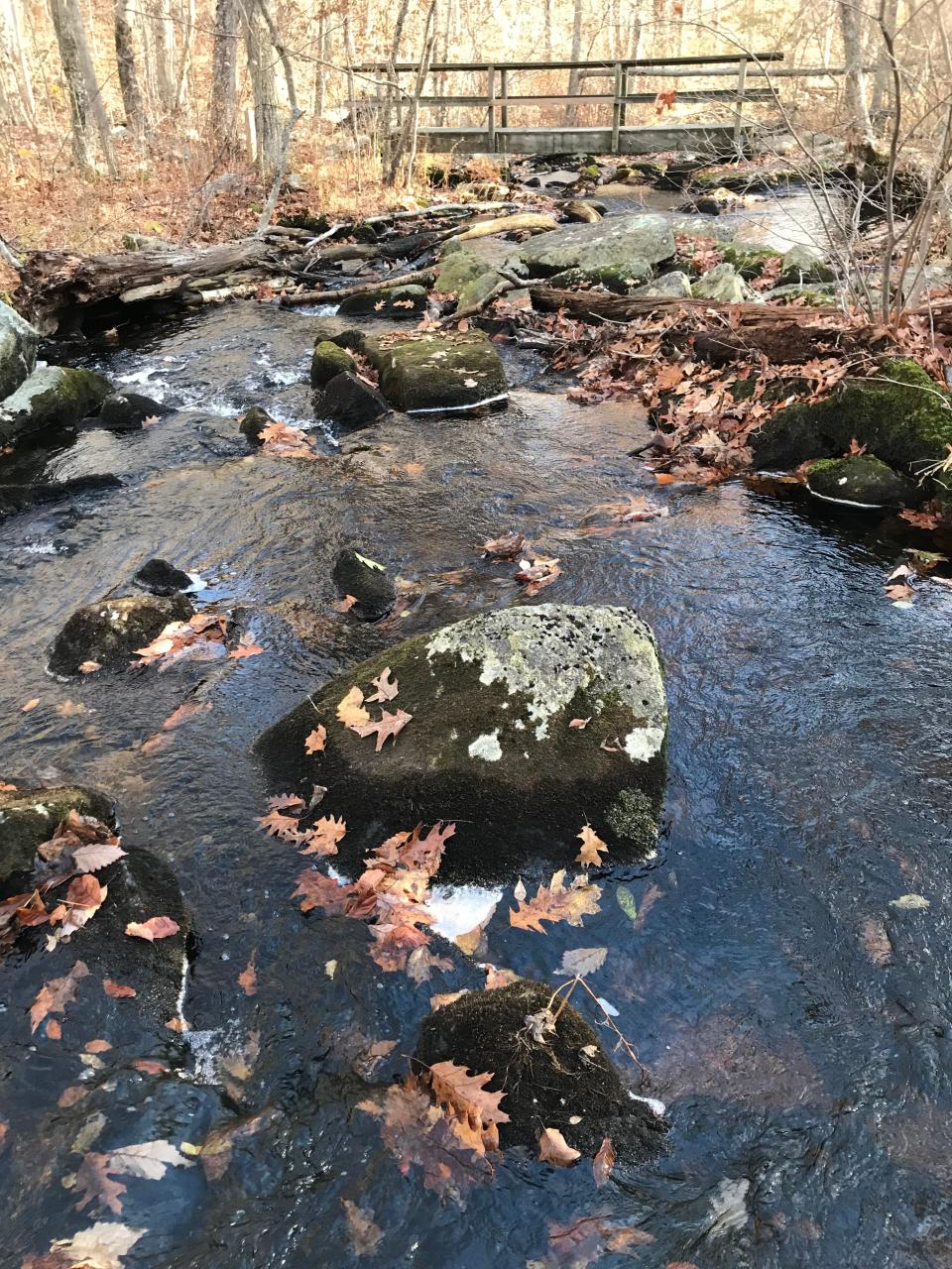
COVENTRY – Pine Swamp Brook cascades down a rocky ravine, creating waves of whitewater and dozens of mini waterfalls before merging with Turkey Meadow Brook, which flows on to the Flat River.
I hiked along the banks of both brooks to get to the start of the Foster Loop in the George B. Parker Woodland Wildlife Refuge, managed by the Audubon Society of Rhode Island. Along the way, I explored farmhouse foundations, stone walls, a quarry and an unusual earthen mound left by late 18th-century and 19th-century farmers.
Some of the natural and man-made features are hidden deep in the woods in most seasons, but they are easier to spot in the winter after the leaves fall from bushes and trees.
I set out early one morning with hiking buddies George, Rick and John C. from the trailhead at Parking Lot 2 off Maple Valley Road. There’s a kiosk there with paper trail maps and some history of the preserve.
A few steps down the yellow-blazed trail, you can see the remains of what looks like an unfinished stone foundation built into a ledge on a rise on the right. I don’t know if there was ever a building there or who did the work, but it was a sign of early settlers who once lived and worked on the hilly and at times rugged terrain.
What's the story behind that mound of soil in the woods?
We followed the path to a marker on the right that pointed out a semicircular, man-made mound in the woods. In 1983, Brown University students conducted an archeological dig of the wide mound and took a core sample of a blackened mix of soil. They concluded that it was the residue of a burned-off charcoal pit.
Farmers in the late 18th and 19th centuries supported their off-season incomes by running small-scale woodland businesses, such as charcoal processing. They created charcoal by stacking hardwood and then covering the pile, which was about 20 feet across, with soil. Then they fired the pile, and it took up to two weeks to make the charcoal, which was sometimes sold to mill owners to fuel furnaces. The shallow ditch around the mound was left from the dirt they shoveled to bury the stack and channel off rainwater
After some inspection, we returned to the trail, which sloped downhill to reach the rapid-running Turkey Meadow Brook. We crossed a sturdy, wooden footbridge and climbed a hillside for a short distance to a junction with the blue-blazed trail. To the right, the trail follows the Coventry Loop and passes by dozens of cone-shaped stone cairns in no apparent pattern. Historians are uncertain if they were left by Indigenous people, Colonial settlers or somebody else. But I’ve hiked that trail many times before, so we decided to turn left to head toward the lesser-known Foster Loop.
More: These 10 Rhode Island trails should be on your bucket list
The blue-blazed trail rose high above Turkey Meadow Brook on the right and crossed Biscuit Hill Road, which, according to legend, was named during the Revolutionary War when a wagon filled with biscuits bound for General Rochambeau’s troops overturned and spilled across the hillside.
A giant relic of an Ice Age glacier
The path turned north through the woods until it came to a giant erratic, dropped by receding glaciers during the Ice Age.
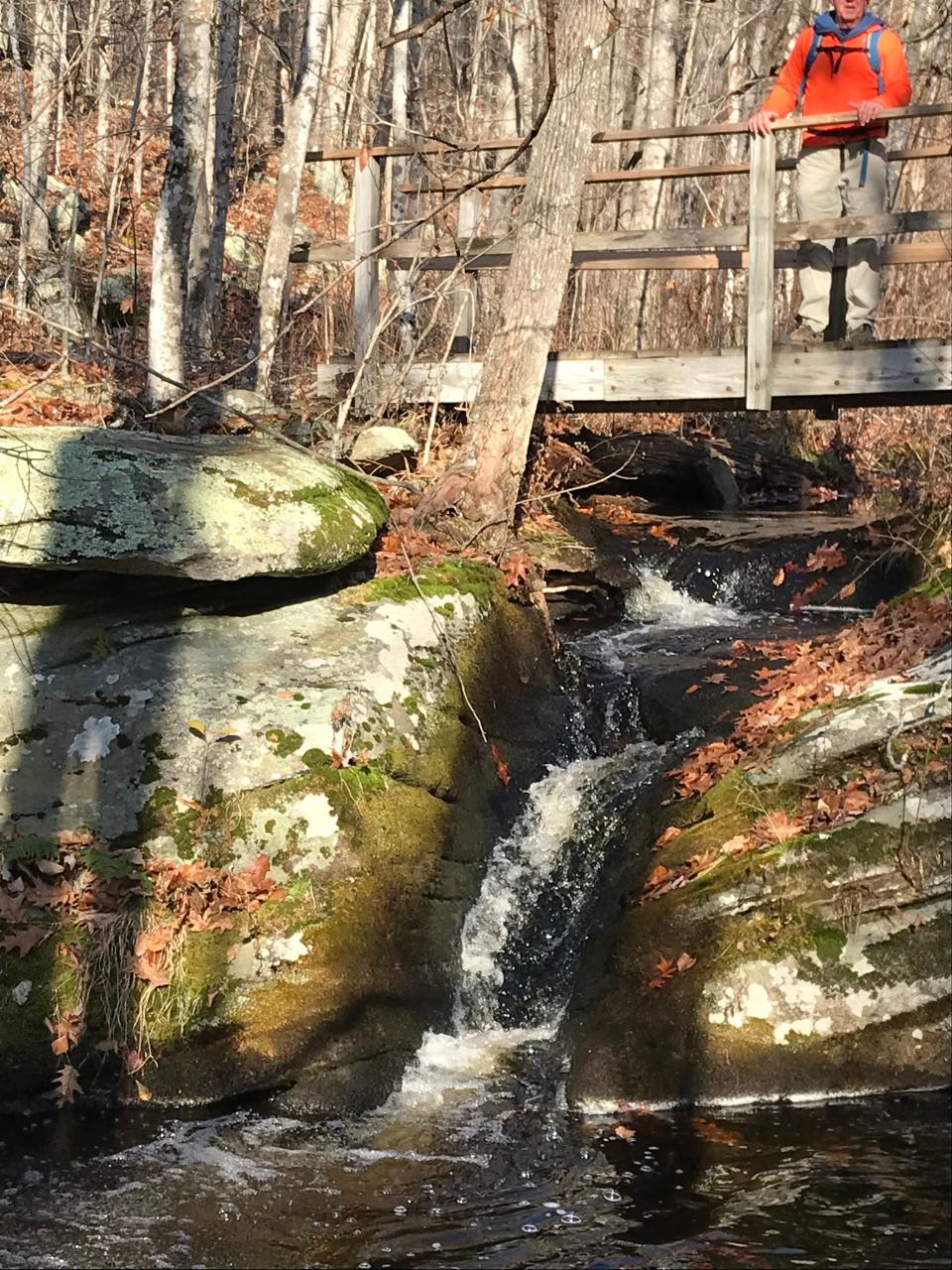
Turning right, we walked downhill to Pine Swamp Brook and followed it upstream through beds of decaying ferns and over moss-covered stones to a wooden footbridge. The fast-flowing brook had sculpted a groove in an outcropping under the bridge and filled a small pool that glimmered in the sun.
It’s a beautiful spot, and I could picture tired hikers in the summer cooling their feet in the cold water. But not in winter.
Trail named for longtime volunteer
We crossed the bridge and followed the yellow-blazed connector trail through onetime farmland that is now covered by a second-growth forest before reaching the start of the blue-blazed Foster Loop, also known as the Milton A. “Hank” Gowdey Memorial Trail. He was a truck driver who lived across from the preserve and volunteered to maintain the trails for 30 years until the week before he died in 1991 at age 72.
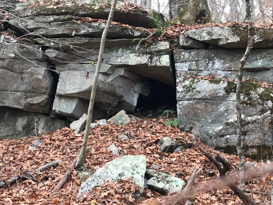
The flat path, covered with oak and beech leaves, crossed Pig Hill Road and passed the first of several stone fire pits left from modern-day campers. As the path turned north, we followed the base of a long, high, granite ledge that was pocked with cracks, crevices, clefts and caves.
Walking RI: A birder's paradise by the shore in Middletown
Farther ahead on the right are some cut and broken stones, some in piles, that remain from a small quarry.
A little after that, the trail again crosses Pig Hill Road, also called Thomas Parker Road in some sections, and passes a three-sided stone foundation that was probably once a barn.
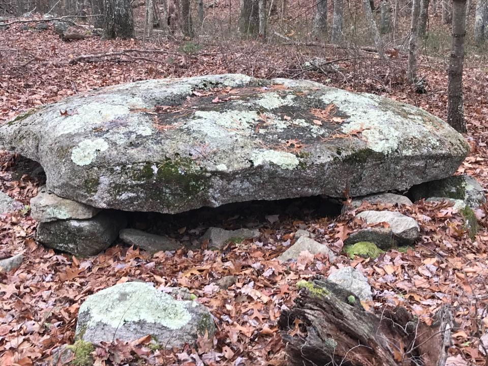
Be sure to check out Table Rock
The trail then winds through a pine forest and reaches a sign on the right for Table Rock. We took the 50-yard path to a large, circular slab of granite laid flat and supported by smaller round stones. Some say it was built by the Narragansetts, but I’m not sure.
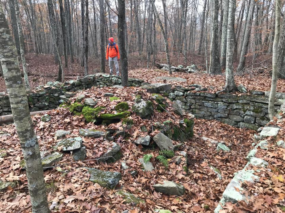
Returning to the blue-blazed trail, we found a network of stone walls and a cluster of foundations that must have once been a farm community. We walked through the area and found a wellhead, rock-wall pens, stone laneways and several chimneys.
After some exploration, we continued on the trail downhill to an upper section of Pine Swamp Brook, which runs from the north. The rocky path climbs again and is marked in places with white, smooth stones, perhaps limestone or milky quartz, before returning to the junction we had passed earlier.
We walked back down the hill to Pine Swamp Brook, crossed the bridge and climbed to the huge erratic. At the boulder, we took the yellow-blazed trail to Biscuit Hill Road and turned left to follow the wide road downhill. As we approached Turkey Meadow Brook, we could see through the trees the remains of a sawmill complex, including stone walls, a sluiceway and perhaps a cavity for a waterwheel.
From there, we turned right on the blue-blazed trail we had hiked earlier and retraced our steps – first back to the bridge over Turkey Meadow Brook and then to the parking lot.
In all, we had hiked 5.5 miles over 3.25 hours.
The special pleasures of a winter hike
Winter hikes are special. The sunlight streaks through the leafless branches of tall trees. The air feels crisp and clear. The only sounds you hear are the occasional call of a bird, the crunch of your boots on thick beds of dried-up oak and maple leaves, or the splash of icy brooks tumbling over rocky streambeds.
And then there are the quiet spots to pause, explore and think.
The Foster Loop has all that, and more.
If you go ...
Access: From Interstate 95, take Route 102 north into Coventry. Turn right on Maple Valley Road and drive a half mile to Parking Lot 2 on the left.
Parking: Available in a lot.
Dogs: Not allowed.
Difficulty: Moderate, with some rocky, rooted trails and climbs up and down hillsides.
GPS Coordinates: 41.7164, -71.6982
'Walking Rhode Island' book
John Kostrzewa’s new book, “Walking Rhode Island: 40 Hikes for Nature and History Lovers with Pictures, GPS Coordinates and Trail Maps,” is available at local booksellers and from Amazon.com.
John Kostrzewa’s column runs every other week in the Rhode Islander section of the Providence Sunday Journal. He welcomes email at johnekostrzewa@gmail.com.
This article originally appeared on The Providence Journal: RI farm ruins and beautiful brooks at Foster Loop trail in Coventry

