A trio of bridges carry you back to RI's past at Grills Wildlife Sanctuary in Hopkinton
HOPKINTON — The three unique bridges that cross brooks and a river in the Grills Wildlife Sanctuary offer clues about who lived and worked on the land.
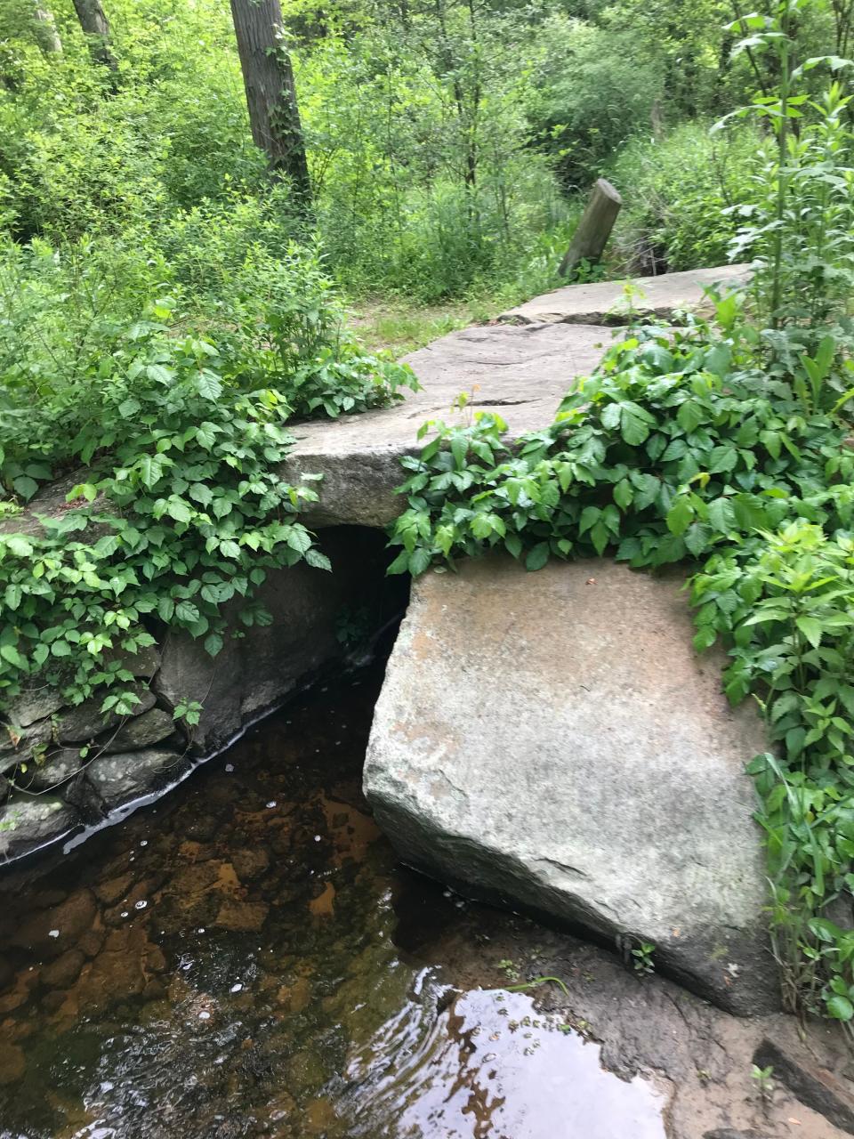
Stone slabs laid over Wine Bottle Brook allowed early farmers to drive their wagons laden with crops from the fields to markets.
Tall, stone abutments on the banks of the Pawcatuck River supported a bridge built in the mid-1800s for teams of oxen to haul granite from a quarry to a railroad siding in Bradford.
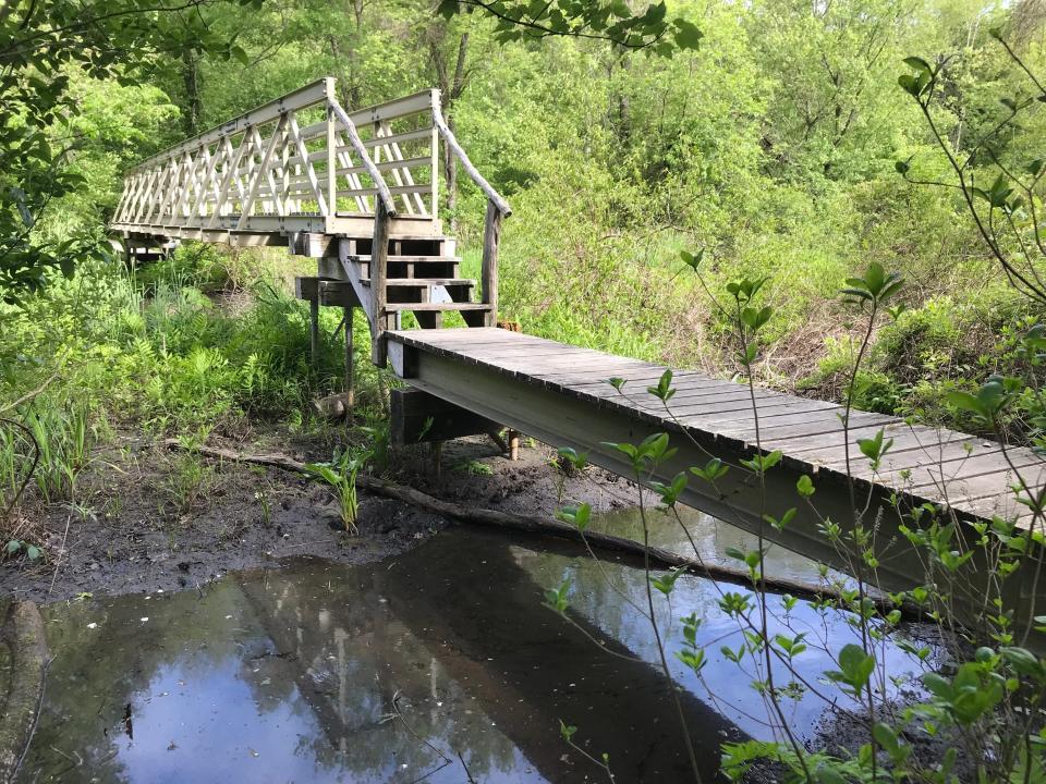
More recently, conservationists built a long boardwalk and elevated bridge to allow hikers to cross the Tomaquag Brook and surrounding wooded swamps.
Walking RI: See ospreys and 300-year-old trees on a pair of family-friendly hikes in Portsmouth
The bridges in the preserve are connected with trails that run across fields and ridges and pass under forests of oak, beech and pine, with birches mixed in. The trees form a thick, shady canopy that create a pleasant walk on a summer morning, but it was the bridges, and their links to the past, that caught my attention.
Old farm bridge over Wine Bottle Brook gets an update
I set out with my hiking buddy Jeff from the trailhead next to a canoe/kayak launch and a pair of picnic tables on the banks of Tomaquag Brook. Tomaquag, spelled Tummockquanogut during the Colonial period, means “place of beavers” in the Narragansett language.
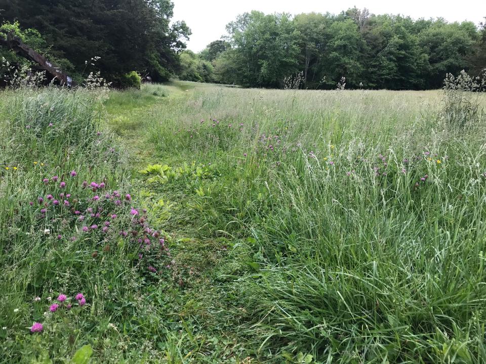
The Tomaquag Trail, blazed with white diamonds, starts out by circling a mowed meadow on the right, which is filled with wildflowers and native grasses, and then passing larger fields on the left that are sometimes planted with corn.
Walking RI: NY philanthropist willed his 1,800-acre estate to RI in 1937 as a sanctuary
Entering the woods, the old cart path leads to Wine Bottle Brook, a tributary of Tomaquag Brook. Volunteers from the Hopkinton Land Trust, which manages the property, renovated an old bridge by laying three stone slabs, each about 5 feet by 4 feet, on a rebuilt foundation. The repairs made the crossing easier and allowed heavy equipment to reach the Tomaquag Brook to build a bridge there. (More on that later).
The trail led to a junction, with a map posted at a kiosk, and we took the orange-blazed trail south through lowlands and a white cedar swamp. Eastern white pines and oak trees dominated the forest, and I saw only a few cedar trees on the left.
Tomaquag Brook Bridge offers all-season crossings of floodplain
At the next junction at an open area with picnic tables, we picked up the white diamond trail again and passed an engraved stone for the Tomaquag Brook Bridge, dedicated to the vision and leadership of Harvey T. Buford, a conservationist and chairman of the Hopkinton Conservation Commission.
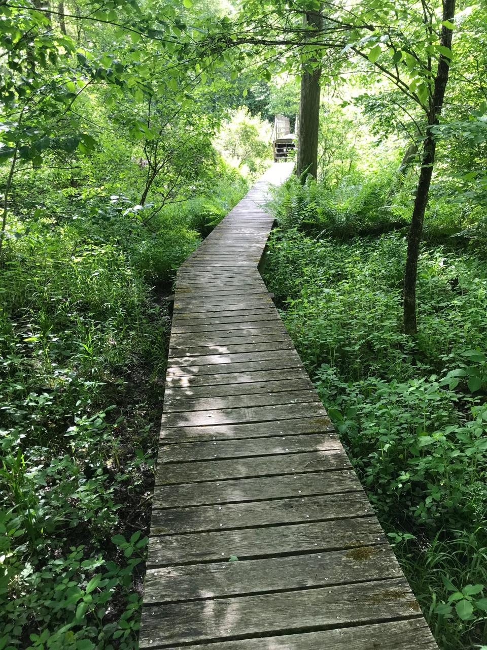
We followed a long, wooden-slat boardwalk above a swampy area thick with vegetation and spotted many deer hoof and paw prints in the mud at the edge of the watering hole. The walkway then climbs four steps, with natural branches as railings, to an elevated bridge over the brook.
We spent some time inspecting the composite construction materials. A lengthy boardwalk extends on each side of the bridge, and I learned later that during a dry period in November 2013, volunteers screwed what’s called helical piles into the ground to support the beams under the walkway.
Walking RI: Hike near the Charlestown hatchery that once helped stock trout across Northeast.
Before the bridge was built, hikers had to wait for dry seasons to cross the wide floodplain along the brook. But now, hikers can cross the brook and wetlands and walk across the preserve from the trailhead off Chase Road to the Pawcatuck River.
The trail on the other side of the bridge crosses and runs parallel to stone walls and turns rocky as it climbs ridgelines and descends into valleys. Between the hills, plank bridges cross streams, but clearing small rivulets required some rock-hopping.
The trail climbs to a high overlook on a ledge with a picnic table — a good place to rest while getting a good view of the valley below and across the landscape.
All the land was inhabited for thousands of years by the Narragansett and Niantic tribes before the arrival of the early settlers and farmers. Later, in the 1800s, Gilbert Burdick and George Burdick owned much of the property, according to Lorraine Arruda, president of the Hopkinton Historical Association. Charles Burdick leased some land to Richard Opie, who ran a quarry there.
Summer Bucket List: How to make the most out of summers in Rhode Island
To the north is Chase Hill (187 feet), where members of the Grills family lived. Richard Grills, a Westerly High School graduate and U.S. Navy veteran, owned the Bradford Dyeing Association and transferred hundreds of acres that created The Grills Preserve in Westerly and The Grills Wildlife Sanctuary in Hopkinton.
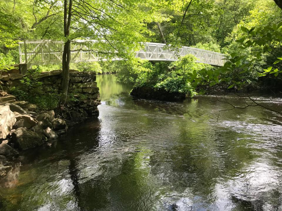
Modern elevated bridge built by conservationists
After a long look at the terrain, we followed the trail up a hillside to a T-intersection that connected with a wide, grassy farm road. We went left and south down a long, easy grade to reach the fast-flowing Pawcatuck River, which runs for 34 miles, starting at Worden Pond in South Kingstown, before emptying into Little Narragansett Bay.
On the right is a vertical stone slab carved to mark the high point of the 2010 flood. Below the marker on the riverbank is what looked like a stone foundation.
Walking RI: Former RI governor's estate Canonchet Farm is a great nature classroom for a family hike
But the real attraction is the arched, 75-foot, aluminum Polly Coon Bridge that glistened in the sun. The bridge rests on old stacked-stone abutments on either side of the river. A third foundation in the middle of the river is also part of its history.
The first bridge on this spot was built in the mid-1800s for oxen to haul granite slabs from the Opie quarry in Hopkinton to the railroad station in Bradford. Floods washed out that bridge, and it was replaced in 1893 by a new higher bridge, which later was removed.
The current bridge was built in 2013 and is named for Patty Coon and Polly Burdick, who lived nearby.
We crossed the footbridge into the Grills Preserve in Westerly and noted an 8-foot cairn built of stones to mark the high-water level in 2010. There’s also a kiosk with a map of the preserve and some history about the area’s earliest settlers, including Edward Larkin, who ran a farm in the 1660s after acquiring 1,800 acres — part of what was called the Misquamicut Purchase — from the Narragansetts.
Because I had hiked through the Grills Preserve in 2021, I turned and retraced my steps. Back on the Hopkinton side of the river, we explored a short path upriver and found a rope swing and a platform built into an oak tree trunk for launching swimmers over the water.
On the way back on the white-diamond Tomaquag Trail and after the bridge, we turned right on the yellow-blazed Peninsula Loop that ran to an oxbow in the river and then back to the white-blazed trail.
Walking RI: Up for a challenge? Tippecansett South Trail is a rigorous, rewarding workout
A short distance later, we turned onto the East Loop that passed through shrubs, a pine forest and quite a few snags of dead oak trees. Tweets from songbirds filled the brush.
We returned to the trailhead after walking about 5 miles over 2.5 hours with many streams, brooks and rivulets that all flow south to the Pawcatuck River. The waterways are fun to cross, but stop for a few minutes to study the bridges. They’re unique, and the differences help tell us who built them and why.
If you go ...
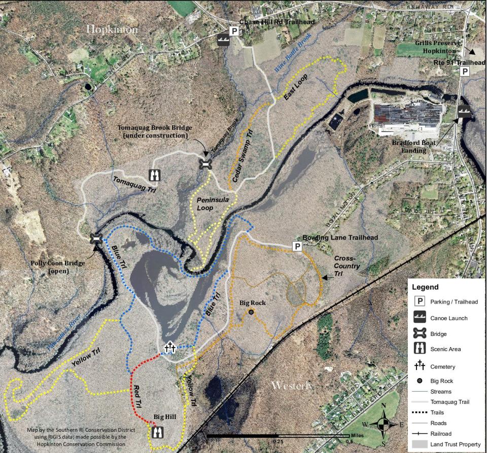
Access: Off Interstate 95, take Route 3 south and turn left on Route 216. Drive several miles and bear right onto a connector to Chase Hill Road. The trailhead kiosk is on the right.
Parking: Available at the trailhead.
Dogs: Allowed but must be leashed.
Difficulty: Easy to moderate over rocky ridges.
Trailhead GPS: 41.410780, -71.763500
John Kostrzewa, a former assistant managing editor at The Providence Journal, welcomes email at johnekostrzewa@gmail.com.
This article originally appeared on The Providence Journal: 3 scenic bridges at Grills Wildlife Sanctuary are links to RI history

