A spectacular hike in Westerly puts the collaboration of conservationists on display
WESTERLY – When my brother Peter visited recently from Florida, I wanted to show him an example of land preservationists working together to protect a watershed, natural habitats and historic sites.
I found what I was looking for by hiking through four adjacent areas owned by the Westerly Land Trust, the Rhode Island Department of Environmental Management and the Town of Westerly.
During our hike under maple, oak and beech trees, we spotted the remains of a 250-year-old mill, crossed bog and stone slab bridges and stood high above water tumbling over the last dam on the Pawcatuck River.
The sites, and the views, were spectacular, but we were also impressed that almost everything we saw was on protected, public lands that anyone could enjoy.
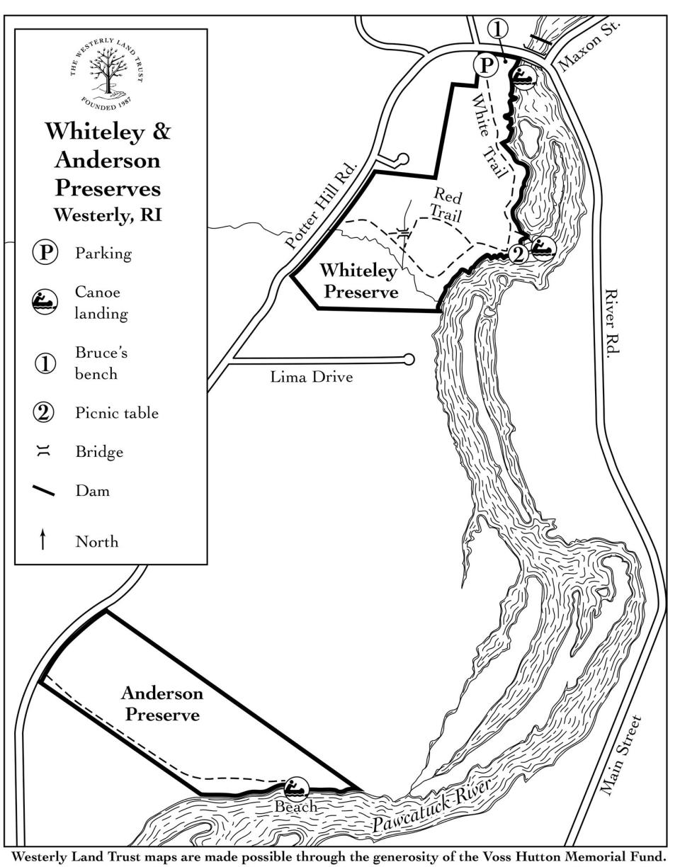
Peter and I set out with our guide, Jeff Walker, a board member of the Westerly Land Trust, from a trailhead off Potter Hill Road and entered a preserve named for Flora Whiteley, who bought the land in 1946. After she died, her descendants transferred 12.1 acres to the Westerly Land Trust, which now manages the sanctuary.
We followed the white-blazed trail through a carpet of ferns and under thick woodlands to a fork. We chose the path to the right and soon crossed a wooden bridge over a stream that ran to the Pawcatuck River.

The path led us to a canoe launch on the riverbank, with a picnic table under a shady spot and a rope swing hanging from an oak that bent over the river. The water flowed slowly by and was dotted with red, orange and gold leaves that had drifted down from the trees. Across the river is Hopkinton.
Bridges, stone walls and signs of the Ice Age
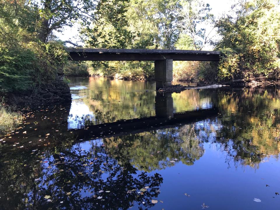
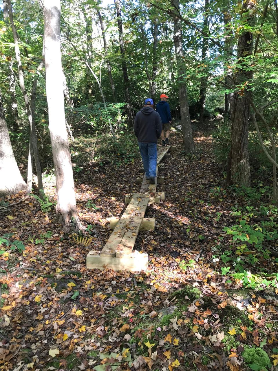
Continuing on, we crossed some lowlands on narrow, wooden plank, bog bridges built by an Eagle Scout and emerged from the woods at a small field partially ringed with a low stone wall. There was a bench and a kiosk on Potter Hill Road. We turned right and crossed a bridge over the Pawcatuck River, which begins at Worden Pond and flows for 35 miles to its mouth at Little Narragansett Bay. Over its course, the river twists and turns in different directions around the Charlestown Moraine left by the Ice Age’s glaciers and Potter Hill, also called Mount Moriah, which is the high point of Westerly at 252 feet, before turning west and south along the border with Connecticut.
On the east side of the river is an old, concrete fish ladder built in the early 1970s for river herring, American shad, trout and other freshwater fish. DEM’s Division of Fish and Wildlife monitors migratory fish and partnered with the U.S. Fish and Wildlife Service to install video monitoring systems to track fish that return to the lower sections of the river.
Vestiges of an old mill, picturesque dam
In the distance, on the west side of the river, a brick chimney pokes up above the trees. The smokestack is one of the last vestiges of an old mill. Owned by the Potter family until 1843, it started out as a grist mill in 1762 before being converted to textile manufacturing. The dam on the river created the waterpower to run the mill.
At the turn of the 19th century, workers at the mill built sloops and schooners for the cod fishing industry and then gunboats for the War of 1812. At its peak, the mill complex had two stores and boarding houses for about 300 mill workers. The Pawcatuck Woolen Mill Company manufactured wool yarn and cloth there until 1958 when it closed.
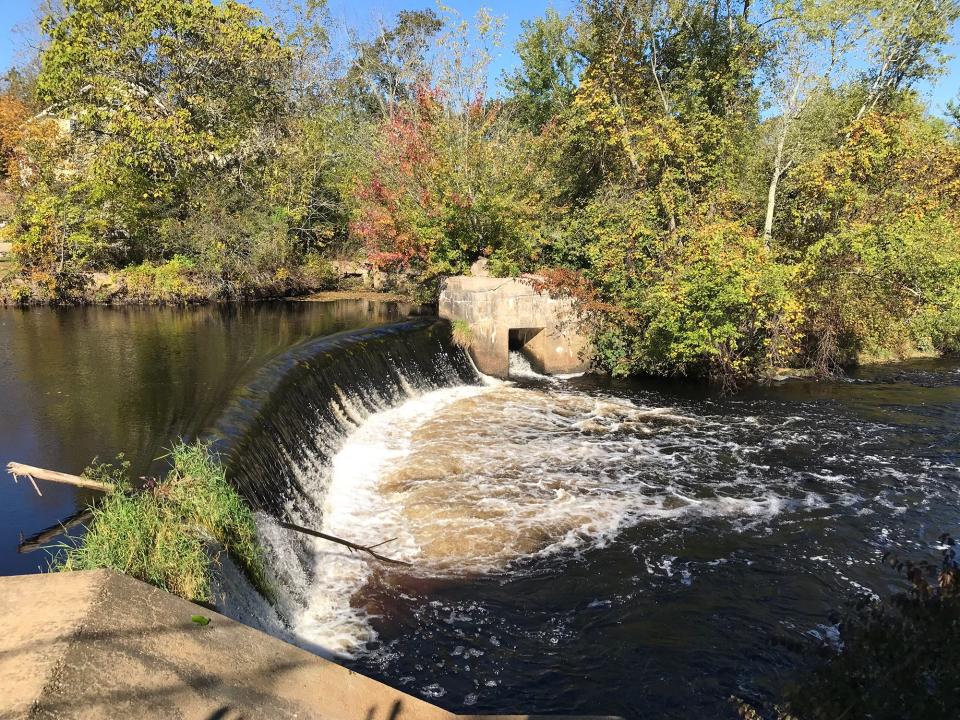
Looking down from the bridge, a cement pillar engraved with 1903 is visible on the left side of the dam. The river crashes down about 10 feet over the dam, creating quite a bit of white water before smoothing out downstream.
As picturesque as it is, the dam, owned by the Town of Westerly, has been a matter of dispute.
Several years ago, environmentalists proposed taking down the old dam to restore the river’s natural flow, which would reestablish wetlands flooded by the dam and allow migratory fish to swim freely up the river.
But riverfront property owners argued that taking it down would lower water levels and affect wells and valuable waterfront property. Other opponents to the plan said there was no evidence the dam was at risk.
The DEM classifies the dam as “low hazard,” which means a failure would not likely result in loss of human life or cause major economic damage. No current plans have been submitted to the DEM to remove the dam.
Through Potter Hill Village
After taking a long look and thinking about the dam’s history, we turned and walked up the road through Potter Hill Village. At an old, two-story building being renovated, we took a right on Post Office Lane and walked down the dirt path past buildings on the right to a grassy bank along the river. The area, called Potter Hill Landing, is a fishing area and a put-in for kayaks and canoes. It covers 4 acres with 625 feet of river frontage and was purchased by the DEM in December 2012 for $195,000 using state bond funds.
A side path took us to a narrow, cement bridge, supported by a long iron beam, that crossed high above the river. We walked to the center of the bridge and saw stubs of stalks in cornfields on the far side of the river and some construction equipment.
The bridge was once used to move cows across the river. Adjacent to the bridge, a huge tree with bark similar to a sycamore tree, but with huge green leaves, hung over the river. Some quick research told us it may be a sycamore maple.
Cottrell family adds to Westerly Land Trust
We retraced our steps to Potter Hill Road, turned right on Christian Hill Road for a short distance and then entered the Cottrell Family Preserve on the left. Nickolas Cottrell purchased the land in 1948. After he died, his descendants transferred 22 acres to the Westerly Land Trust and retained a homestead on another 32 acres.
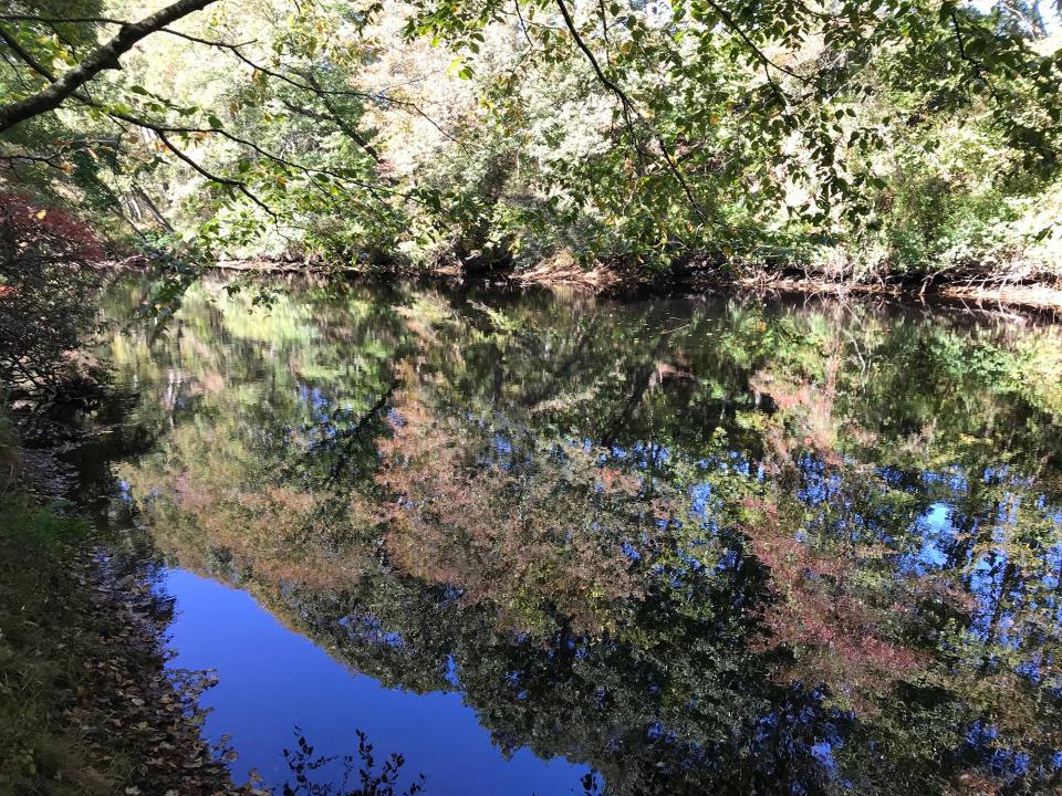
We walked north along the edge of a large hay field where the Westerly Land Trust is working to remove invasive plants and regenerate native grasslands. The path led to an opening in the trees along the banks of the Pawcatuck River, where we found a small fire pit. We then followed the blue-blazed path northwest along the riverbank. Several openings in the trees and shrubs gave us great views of the water slowly meandering to the west.
After passing through some wetlands, we turned and retraced our steps back to a yellow-blazed trail on the right and took it to a red-blazed loop trail that ran along stone walls and rose and fell over small hills and ridges. At one point, we crossed a wide lane that years ago may have been used by farm wagons. At another spot, a stream ran under a stone slab and earth bridge. The stream, brooks and other intermittent streams that cross a hillside create a large watershed that drains to the river.
Hiking in RI: What lies beneath Barrington's Sowams Woods? Why this nature preserve is a sacred spot.
We walked to the property line at the western edge of the preserve and in the distance spotted an abandoned rusted pickup truck.
We turned south and then east. Near the end of the red-blazed loop, we took a right on a trail that led through a small slice of the 200-acre Town Forest owned by the Town of Westerly. Under a partnership between the town and the Westerly Land Trust, the land trust maintains the trail and hopes to connect the trail system to other parts of the Town Forest.
The last section of our hike crossed small ridges, marked with pink ribbons in some places. The path ran up and down a hillside to a recently cleared small lot where we had parked.
A collaboration to preserve best of RI
In all, we hiked about 2.9 miles for about two hours.
After our hike, I talked with Marc Doherty, land stewardship manager at the land trust, who said recent surveys of the preserves recorded a rare species of Amanita mushroom that is perhaps the first such specimen found in the state.
He added, “... It is quite nice to have some contiguous conserved land in this area of town. While none of WLT's parcels are considerably large, they do connect with other conserved parcels, such as the Town Forest and adjacent WLT properties and provide a nice wildlife corridor between different habitats - from the upland forests, to early successional habitat along the old fields, and all the way down to the wetlands and riparian zone of the Pawcatuck River.”
Well said.
My brother Peter, who hikes mostly in Florida through flat, sandy scrubland, enjoyed the change of pace. He also learned a lot about the collaboration of conservationists to protect what is best about Rhode Island. I hope that hike gave him plenty to think about on his way home.
If you go…
Access: Off I-95, take Route 216 south to Laurel Street. Turn left on Potter Hill Road to a small lot on the left.
Parking: Available for several cars.
Dogs: Allowed but must be leashed.
Distance: 2.9 miles
Difficulty: Easy on mostly flat, well-marked trails.
GPS Coordinates: 41.41224, -71.80043
Lectures and signings for 'Walking Rhode Island' book
John Kostrzewa’s new book, “Walking Rhode Island 40 Hikes for Nature and History Lovers with Pictures, GPS Coordinates and Trail Maps” is available at local booksellers and at Amazon.com. He’ll sell and sign books after these presentations and slideshows about his hikes:
Tuesday, Nov. 7 - Harmony Library, Glocester, 6 p.m.
Thursday, Nov. 9 - Willett Free Library, Saunderstown, 4 p.m.
Monday, Nov. 13 - Louttit Library, West Greenwich, 6:30 p.m.
Wednesday, Nov. 15 - Charlestown Land Trust, Kettle Pond Visitors Center, Charlestown, 5 p.m.
John Kostrzewa’s column runs every other Sunday in the Rhode Islander section of The Providence Sunday Journal. He welcomes email at johnekostrzewa@gmail.com.
This article originally appeared on The Providence Journal: Westerly RI hikes: Whitely, Cottrell preserves show town's history

