Mississippi tornado's violent path shown in jaw-dropping satellite images

An EF4 tornado tore through the western Mississippi town of Rolling Fork on Friday night, causing total destruction as it ripped through the small, tight-knit community. The outbreak of storms left 21 dead across Mississippi, and communities face a lengthy road to recovery.
The images from the ground and drone footage taken in the tornado's aftermath have revealed startling damage as the twister laid waste to homes and businesses. Neighborhoods were flattened. A truck was tossed on top of a building like a toy. Large pieces of wood impaled a vehicle. But also pictured were resilient communities coming together and beginning to pick up the pieces.
 |
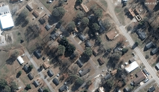
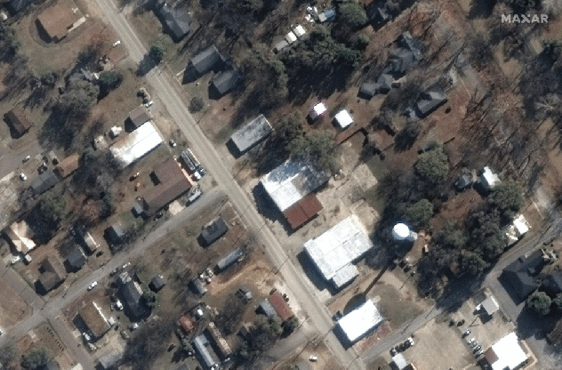
Dramatic before and after satellite photos of Rolling Fork, Mississippi, tornado. Before photos were taken on Dec. 27, 2022. After photos were taken on March 26, 2023. (Satellite image ©2023 Maxar Technologies) |
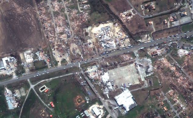
Dramatic satellite imagery released on Sunday by Maxar shows a different perspective of the tornado's wrath. From a bird's-eye view, the extensive damage to buildings in Rolling Fork is hard to miss, and the EF4's nearly 60-mile path of obliteration can be seen clearly.
The jaw-dropping photos illustrate the twister's violent path. Beginning in northern Issaquena County and ending to the northeast in northern Holmes County, the path was approximately 59.38 miles long, according to the storm survey from the National Weather Service (NWS). The maximum path width of the storm was three-quarters of a mile, and the tornado lasted for approximately 70 minutes.
 |
The tornado was given an EF4 rating, with estimated peak wind speeds of 170 mph.
Baeley Williams, one of the emergency responders in Rolling Fork, told AccuWeather National Reporter Bill Wadell that the town was "unrecognizable" when she arrived.
"There's houses completely demolished. There's businesses demolished," said Williams. "Most of the town is unrecognizable right now. They can take all of the help they can get."
 |
Before and after satellite photos of Rolling Fork, Mississippi, tornado. Before photos were taken on Dec. 27, 2022. After photos were taken on March 26, 2023. (Satellite image ©2023 Maxar Technologies) |
In a Monday press release, Mississippi Emergency Management Agency officials noted that search and rescue operations were demobilized. The agency coordinated multiple resources to help those impacted, such as providing bottled water, tarps, portable restrooms and fuel for critical infrastructure generators. As of Sunday, at least three shelters were open for storm survivors.
"The devastation here in Rolling Fork is heartbreaking," Mississippi Gov. Tate Reeves wrote on Twitter on Sunday. "The character and generosity of Mississippians is on full display with the countless volunteers and donations being offered."
The Cajun Navy Ground Force, a disaster relief non-profit established in 2016, was one of the many groups on the ground providing help to those affected by Friday's storm.
"I've been to 15 disasters, and as far as tornadoes go, this is one of the worst I've seen," Clint Roe, a Cajun Navy Ground Force volunteer, told Wadell. "A lot of these people lost their cars and aren't able to get their supplies and food, so our job today is to get as much of that out to the community as we can."
 |
Before and after satellite photos of Rolling Fork, Mississippi, tornado. Before photos were taken on Dec. 27, 2022. After photos were taken on March 26, 2023. (Satellite image ©2023 Maxar Technologies) |
Reeves declared a state of emergency in Carroll, Humphreys, Monroe and Sharkey counties due to the extensive damage Friday's storms caused. The White House approved Reeves' request for federal assistance for those impacted counties Sunday morning.
"The images from across Mississippi are heartbreaking," Biden said in a statement released on Saturday. "While we are still assessing the full extent of the damage, we know that many of our fellow Americans are not only grieving for family and friends, they've lost homes and businesses."
Want next-level safety, ad-free? Unlock advanced, hyperlocal severe weather alerts when you subscribe to Premium+ on the AccuWeather app.AccuWeather Alerts™ are prompted by our expert meteorologists who monitor and analyze dangerous weather risks 24/7 to keep you and your family safer.
