A Hiker's Path: Two short but rugged hikes in Clifty Falls State Park
Recently, I decided I would make a trek down to Clifty Falls State Park. It had been awhile since I last hiked there.
The park was established in 1920 and became Indiana's third state park. The purchase of the original 570 acres cost a total of $30,000. The citizens in Jefferson County, Indiana, where the park is located, raised half of the purchase price and the state provided the other half.
The park contains 1,416 acres and has 10 hiking trails.
After the long drive south, I arrived at the park around lunch time. It was a very warm day in June and the sky was sunny overhead. My chosen trail of the day: Trail 4, Hoffman Falls.
The trail started at the Hoffman Falls parking lot and was 0.75 miles in length. This trail is considered “rugged” in ease of hiking. I parked my car and took off on the trail.
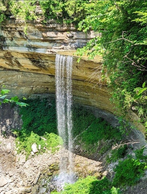
I started by walking down some old stone steps that led me to my first stop: an overlook view of Hoffman Falls. The waterfall is 78 feet in height, quite impressive even though the water-flow this time of year wasn’t as rapid as it might be earlier in the spring. Still, the view was quite scenic.
I spent some time at the falls just to reflect and enjoy the moment.
I continued my hike along the path where the trail followed the deep canyon until it intersected with a trail of stairs leading down to Clifty Creek. The summer landscape was dotted with all shades of green, and evergreen trees and old moss.
With the stone walls of the canyon and the scent of the damp earth, I felt like I was about to enter into some ancient world.
The stairs descended (steeply at times) into a deep canyon, which traverses the entire north-south length of the state park. This particular branch of the canyon is called the Hoffman Canyon. Spectacular views surrounded me, both above and below.
The creek itself ran into the Ohio River, which was not far away. Along the bedrock of the creek, there were also fossils to be explored. This is one of my favorite places to hike, but a place that I don’t visit to often.
When I finally made my way back up out of the canyon, via all of those stone steps, I stopped to visit the Lilly Memorial Overlook. The stonework there was built by Civilian Conservation Corps laborers in 1936. I found a fantastic view of the Ohio River Valley and a nice picnic area.
I took a quick lunch break and then decided to hike Trail 1.
This trail was also 0.75 miles in length and “rugged” to hike. The trail started at the Nature Center Parking lot. I followed the trail and it quickly led me to an observation tower which overlooked the Ohio River Valley.
Of course, I had to climb it to see what was up there. It wasn’t too high but the view was fantastic. Not only could I see the Ohio River, I could also see a great view of the town of Madison, which is right down the road from the park.
The trail continued along the canyon wall, which also included a steep hike in and out of the canyon, and then back to the road. So much to offer from two seemingly smaller trails, though, in reality, you can hike farther on any of the park’s trails. Many of them intersect with one another.
So much left to explore but It was getting late so I knew it was time to go. It had been a good hike.
There is a seasonal admission charge to get into the park, or a state park pass will get you in!
To get to this place: Take Interstate 65 south from Columbus toward Louisville. Take exit 34A onto Ind. 256 East toward Austin. Drive 20.5 miles and turn left on Clifty Hollow Road. Drive approximately 2 miles and you will see the park entrance on your right.
A quote for your week: “The sound of water is worth more than all the poets words.” — Octavio Paz, Mexican poet, 1914-1998
Until the next trail,Susan
This article originally appeared on Evening World: A Hiker's Path: Two short but rugged hikes in Clifty Falls State Park
