A Hiker's Path: Rugged climbs up the Knobstone Hiking Trail
The Knobstone Hiking Trail is Indiana's longest footpath. The original trail is a 58-mile-long backcountry hiking trail that follows a north/south route (or a south/north route depending on where you start) and passes through Jackson-Washington State Forest, Elk Creek Fishing Area, and Clark State Forest.
The current trail extends from Delaney Creek Park just south of Ind. 135 in Washington County to Deam Lake, which is located just north of Ind. 60 in Clark County.
The first 32 miles of trail opened in 1980 and the latest addition of the trail opened in 1999.
Since then, the Knobstone Hiking Trail Association has been working to turn the trail into a 150-mile trail by joining the Tecumseh Trail, which begins in the Morgan-Monroe State Forest and is 42 miles in length.
The KHTA has been working diligently to acquire land easements on private land to complete the trail on sections in between public lands. The trail is narrow and rugged in places, changes in elevation from 535 feet to 1,001 feet, and climbs repeatedly deep into and out again of valleys that follow the trail along tall bluffs or rounded knobs.
Because of its reputation, many people in the region use this trail to prepare for the Appalachian Trail. It's definitely considered rugged.
I had hiked the trail in the past so I knew firsthand about its “ups and downs.”
The good thing about this trail is there are several trailheads that a person can start at, which means the trail can be hiked in sections. That’s exactly what I did when I hiked a section of the Knobstone.
I decided to hike the Spurgeon Hollow section. It was closer to home for me and it offered a couple of different options as far as hiking goes. I could hike an 8-mile loop, hike a ridge top of 5 miles, or as much as I wanted really.
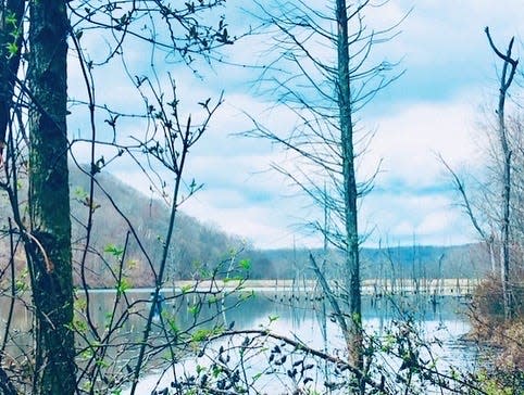
The trailhead is located next to Spurgeon Hollow Lake, which is a small lake located off Ind. 135, northeast of Salem.
After a bit of a drive, I pulled into the gravel lot. I saw several cars parked there.
I came prepared with water and snacks and a few other supplies in a small backpack. By the time I started my hike, it was early afternoon, so I took off down the trail to see what the trail had to offer.
The sky overhead was partly cloudy and the temperature outside was cool enough to wear layers. It was November in Indiana. I dressed accordingly.
I followed the trail as it led me around the edge of the lake. As I walked along the well worn pat, I had nice views of the lake.
A sign pointed in one direction toward the Delaney Park trailhead and the other way led further down the Spurgeon Hollow Trail. I opted to follow the Delaney section. The trail was marked by white blazes on the trees.
I soon found myself walking up a very steep incline. Actually it was a very steep hill and I realized I was climbing up my first “knob” of the trail. A knob is the high point on the top of a mountain ridge, or as in this case, a hill.
There are many knobs on this trail, thus how the trail got its name.
I was wondering if this knob had a name, as many of them do. I was thinking about renaming it while I climbing it, but I will keep those thoughts to myself.
I persevered and made it to the top of that knob. I found myself on a high ridge top with a spectacular view of other ridge tops and valleys. It was definitely one of those defining moments on top of that ridge.
I took more than a few photos and followed the ridge for a bit before turning around. There were beautiful hardwood trees all around me. The forest around me was very quiet.
What an enjoyable day it was.
I decided to turn around and hike back to the fork in the trail. I continued on the Spurgeon Hollow Trail which eventually led me away from the lake and through a deeper part of the woods. I soon came to a creek and stopped to take in the scenery.
I walked along, looking at the forest landscape while the white blazes on the trees that I passed became my constant companions.
It began to get late in the day so I reluctantly turned around and made my way back to the parking lot.
It had been a good day on the trail.
To find out more, go to the KHTA website: www.KnobstoneHikingTrailAssociation.org.
To find this trailhead: Take Ind. 37 south of Bloomington to Bedford. Take U.S. 50 east toward Brownstown. Turn south on U.S. 135. Follow until you come to East Rooster Hill Road and turn left. Follow until you come to North Delaney Park Road and turn right. Spurgeon Lake is on the left.
A quote for your week: “I’ve realized that at the top of the mountain, there’s another mountain.” — Andrew Garfield, actor Until the next trail. Susan
This article originally appeared on The Herald-Times: A Hiker's Path: Rugged climbs up the Knobstone Hiking Trail
