A hiker's path: Overlooking the Ohio River at O'Bannon Woods State Park
O'Bannon Woods State Park is surrounded by the 24,000-acre Harrison-Crawford State Forest which is near Corydon, Indiana (the first state capitol). Located in southern Indiana, both the park and the state forest border the Ohio River.
The Blue River also flows through the park and flows into the Ohio River at its borders.
The park was formerly known as the Wyandotte Woods State Recreation Area. The name was changed back in 2004 to O'Bannon Woods to honor the late Indiana Gov. Frank O'Bannon and his family. It contains 2,294 acres.
The park boasts eight hiking trails.
Native Americans mined the valuable bluish-grey Harrison County flint from the caves and fields for thousands of years to make spearpoints, knives, and arrowheads. Pioneer settlers traveled through the Ohio Valley in the early 1800s. Many settled in the area. The Wyandotte caves are also in the area.The Adventure Hiking Trail in southern Indiana is a 25-mile trail that includes interesting cliff formations, sinkholes, deep ravines, and old pioneer homesteads. It loops through the state park.
The trail travels through the deep forests of the O’Bannon Woods State Park and the Harrison-Crawford State Forest, that are both adjacent to the Ohio River. Some of the best highlights of the trail are the many scenic views from a high bluff above the river’s northern bank.
The trail also offers four shelter houses and some great spots for secluded backcountry camping. This is one of my favorite trails in the park, though I haven’t hiked the whole loop.
My favorite day hike in the park is the “Ohio River Bluff” trail. This loop trail is 1.5 miles in length and is considered rugged in ease of hiking.
I headed down to this park on a beautiful September morning. The temperature was in the 70s and blue skies prevailed overhead. When I arrived at the park, I stopped and acquired a trail map at the gatehouse. I followed the road back to the trailhead.There was a shelter house and a picnic area near the trailhead parking lot.
The trail led me along the banks of the great Ohio River. The river starts in Pittsburg, Pennsylvania, and is formed by the confluence of the Allegheny and Monongahela rivers. It ends in Cairo, Illinois, where it empties into the mouth of the Mississippi River.
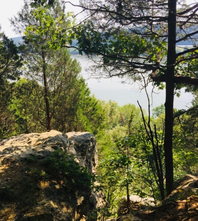
The trail took me by the river on one side and a large, rocky bluff on the other.
The river was in rare form this day with the surface of the water sparkling and the river meandering its way downstream. Late summer plants grew along the sandy banks. It was backwoods Indiana at its finest.I soon came to an intersection of another trail, a bridle trail. There I found a small sign directing me to start an ascension up a somewhat steep bluff. I was thankful when I saw that there were switchbacks cut into the side of the bluff, (zigzag trails for easier climbing). The view as I approached the top was outstanding.
There were some cedar trees along the edge of the rocky cliffs overlooking the river and a beautiful forest on the other side of the trail. I took a lot of photos, though the photos did not do justice to the spectacular sight of the Ohio River Valley that I could see for quite a distance from my vantage point.
I continued on the trail and finally found myself descending an old stone staircase built into the slope.
The old stairs were built back in the 1930s through the work of the 517th Co. Civilian Conservation Corps. These men also planted trees, built facilities, and worked on other projects in the park.
The 517th was one of the few African-American CCC companies located in Indiana and the camp sat where the group camp in the park sits today. When I finally reached the bottom of the stairs, I was back in the parking lot. It had been a great hike.
To get to this place: Take Ind. 37 south. Eventually you will turn left on I-64 East. Then drive about 5.7 miles and take Exit 92 and go right on Ind. 66. After almost two miles, turn left onto Ind. 62 for about a mile and then turn on Old Forest Road. It's about 5 more miles to the park entrance. There are plenty of signs. The address for the park is 7234 Old Forest Road SW, Corydon, Indiana.A quote for your week: "Eventually, all things merge into one, and a river runs through it." — Norman Maclean, American writer, 1902-1990
Until the next trail,Susan
This article originally appeared on The Herald-Times: Hiking in O'Bannon Woods State Park near Corydon, Indiana
