Tour de Romandie 2023 route
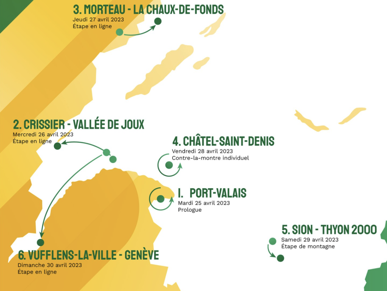
The Tour de Romandie returns for a 76th edition, April 25-30, 2023, with six days of racing across the high alpine mountains of Switzerland that serve as a proving ground for teams looking for climbing and time trialling to prepare for the Grand Tours.
Similar to last year, there are 702.5 kilometres of racing, but 25.5 of that comes across two time trials, an opening prologue in Le Bouveret on the southern shore of Lake Geneva and 18.75 on stage 3.
Last year Aleksandr Vlasov (Bora-Hansgrohe) unseated Rohan Dennis (Jumbo-Visma) in an uphill time trial on the final day of racing to secure the title. This year the moves in the ITT may be negated by big mountains, as the 18.75km race against the clock comes mid-race at Châtel-Saint-Denis to the north-east of Lake Geneva.
Not only are the races against the clock enticing for conditioning prior to the Giro d'Italia as well as the Tour de France, but Romandie packs in 12,991 metres of elevation gain across the six days. After the second ITT a giant mountain contest looms from Sion to Thyon 2000 for the penultimate day that finishes at 2,000 metres. The decisive stage 5 is a hilly finale that leads to Geneva.
Prologue: Le Bouveret, Port Valais to Le Bouveret, Port Valais
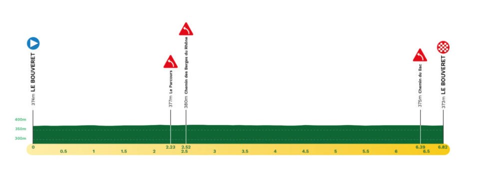
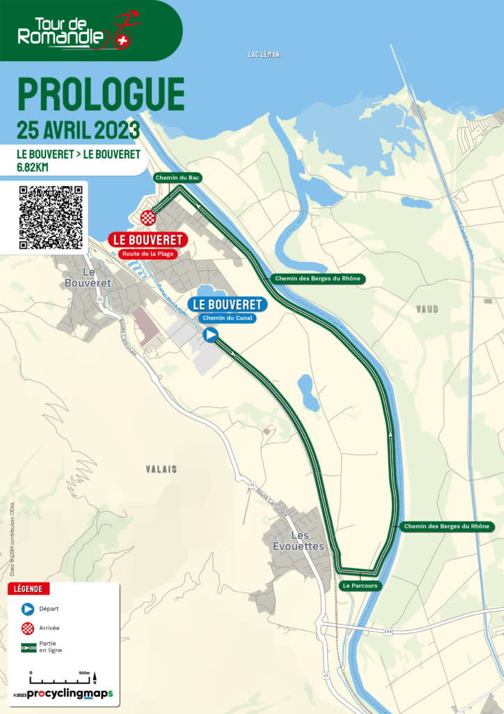
The week begins with a long but flat prologue, 6.8km in the village of Le Bouveret, tucked on the southernmost end of Lake Geneva in Port-Valais.
The opening kilometres head south and then turn after 2.5km to follow the Rhône River as it empties into the lake. Like the river waters, the riders will rush to the finish on the banks of Lake Geneva and set early GC expectations in the city centre of Le Bouveret.
Stage 1: Crissier to Vallée de Joux
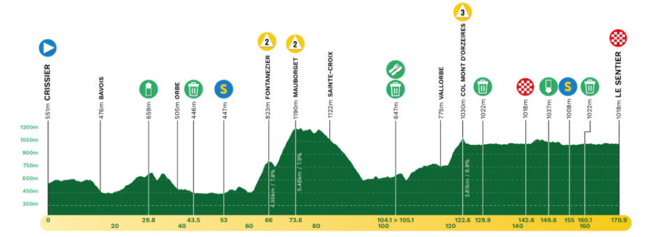

The second day of racing is a hilly day of 170.9km from Crissier to La Vallée de Joux (Le Sentier) that the sprinters may survive.
The first set of category 2 climbs hit just 7.5km apart in the first half of racing, the Fontanezier (4.5km at 7.8%) and the Mauborget (5.4km at 7.9%), the second reaching 1,190 metres. Another 50km later, with a long descent from Sainte-Croix leading to Vallorbe, the Col Mont d’Orzeires (3.8km at 6.9%) must be crested to clear the way for the finale.
It is a relatively flat 48km to thesouth shore of Lac de Joux, the largest body of water in the Jura mountains. Look for a bunch finish in Le Sentier.
Stage 2: Morteau to La Chaux-de-Fonds
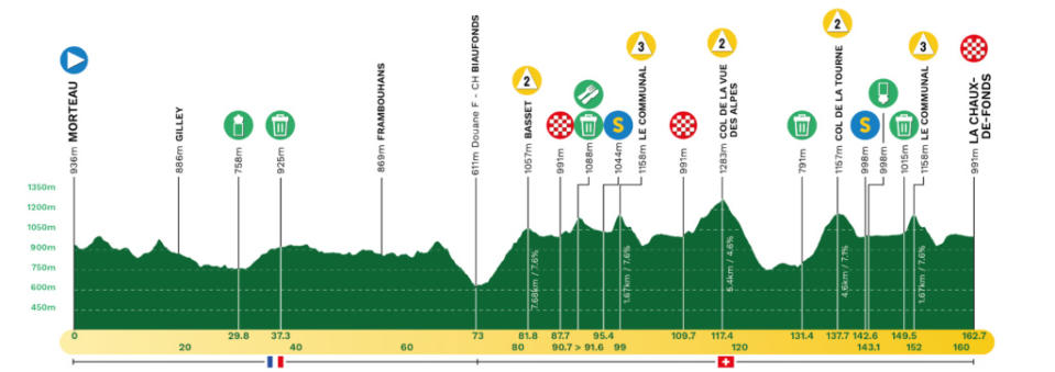

Stage 2 begins in Morteau, France and covers 162.7km of rugged terrain to the Swiss finish in La Chaux-de-Fonds. The first 73km are on French soil and provide rolling terrain to warm the legs for a second half packed with five categorised climbs that provide the bulk of 3,172 metres of elevation gain on the day.
Once crossing the Franco-Swiss river in the tranquil setting of Biaufond, the Swiss roads turn skyward at Basset (7.6km at 7.6%). The first of two ascents of Le Communal (1.6km at 7.6%) come 14km later, with intermediate sprint points on the initial crest. From Col de la Vue des Alpes (5.4km at 4.6%), there is along descent back to the mountains of Neuchâtel via La Tourne (4.6km at 7.1%), then the Communal hill a second time.
The final 10.7km lead directly to the finish at La Chaux-de-Fonds, which organisers have set as a stunning punctuation for their version of ‘Champs-Elysées’.
Stage 3: Châtel-Saint-Denis to Châtel-Saint-Denis (ITT)
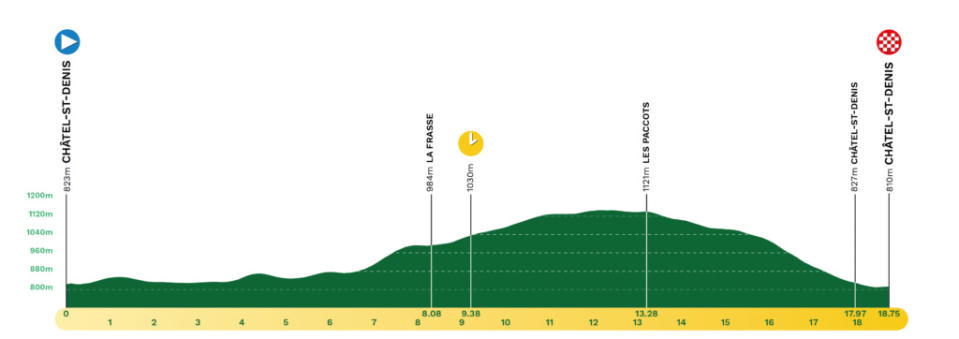

Unlike past years when the individual time trial stage stopped the time and GC outcome on the final day, the ITT is now a mid-race affair. The 18.75km race against the clock is set in Châtel-St-Denis, located between Lake Geneva and the Friborg mountains.
It is a demanding ride that begins with a few flat kilometres. Then, a challenging but not severe climb hits mid-way from Frasse to Les Paccots followed by a technical descent on the final 5.5km to finish.
Stage 4: Sion to Thyon 2000
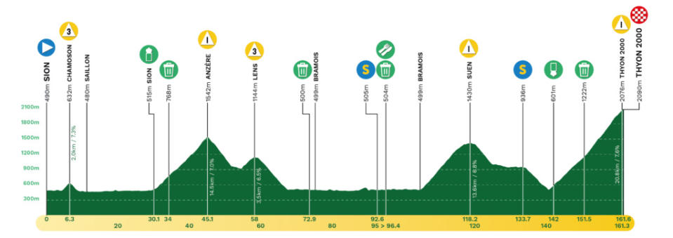

There is a total of 4,345 metres of elevation gain for the queen stage on Saturday. Stage 4, 161.6km, combines a pair of third-category climbs with a pair of first-category climbs in the lead up to a mountaintop finish at Thyon 2000 ski area, located on the western slope of the Val d'Hérens in central Valais with a final 20km all uphill.
Two towering castles of Valère and Tourbillon overlook the start in Sion, which only provides 4km of flat roads before the punchyl category 3 ascent of Chamoson (2km at 7.3%). The road flattens for the next 20km in the approach to Anzère, a long 14.5km ascent that averages 7% and should serve for attacks. Another 10km later is the climb of Lens (3.5km at 6.5%), and then a long descent and valley section with an intermediate sprint leading to the Suen climb, 13.6km with almost a 7% average gradient.
There is another chance for sprint points on the descent, then the signature climb of a little more than 20km to the top of Thyon 2000.
Stage 5: Vufflens-la-Ville to Geneva
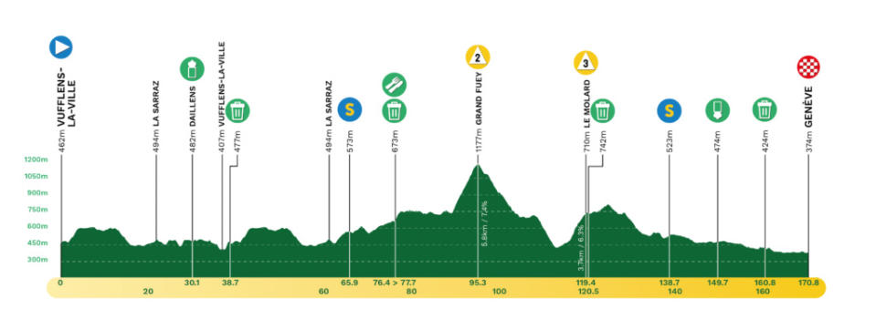
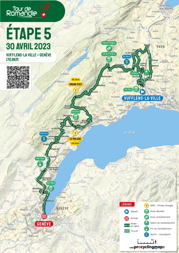
The final day of racing begins in Vufflens-la-Ville in the south-west district of Gros-de Vaud. The valleys and hills set the stage for the sprinters by the end of the 170.8km
Stage 5. It’s a rolling day with 2,506 metres of climbing, but only two classified climbs, the toughest at Grand Fuey (5.8km at 7.4%) just beyond the mid-point of the race. Le Molard (3.7% at 6.3%) follows 25km later, with a few uncategorised hills that lead to the final intermediate sprint just beyond Trélex. From there it is a fast 32km to the finish in Geneva on the Quai du Mont-Blanc.

