Why is Ian’s path to Florida so hard to predict? There’s a reason for the whiplash.
Once upon a time, Hurricane Ian was forecast to go as far west as Biloxi, Mississippi, with impacts reaching the eastern shores of Texas.
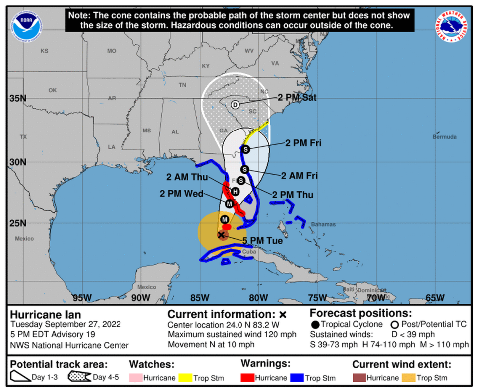
Now, the storm is on track to hit land somewhere south of the Bradenton area as a Category 4 hurricane sometime Wednesday, bringing with it heavy rain, sustained winds of 140 mph, storm surges and even tornadoes.
When exactly will this happen? Unclear. Where exactly? Also unclear. Where will the storm go next? Georgia likely, but it could move back out into the Atlantic Ocean and target South Carolina, too.
There’s a reason why Ian’s track and eventual landfall has been so hard to predict, weather experts say.
National Weather Service meteorologist Rick Davis said the wind currents controlling it have been relatively hard to parse out, in part due to the sheer size of the storm. Those currents could have just as easily taken the storm farther up the Gulf Coast.
“All storms evolve and their steering currents can be very subtle,” he said.
A 40-mile difference in Florida
At its biggest points, the clouds tied to the storm stretch from Cuba all the way up to Washington, D.C. — nearly 1,200 miles and from east to west the storm stretches nearly 500 miles across Florida.
While every day people might feel like the storm’s path has been constantly changing, Davis said the forecast models are much more accurate than in the past.
“Three days ago, the forecast was to bring the storm into Tampa, and now it’s down towards the Venice area. Well, Tampa to Venice is only 40 miles. A 40 mile difference in a forecast track out three days is insignificant,” he said. “But for those of us living in Florida, where the coast runs north and south, 50 miles difference is significant.
“What we’re perceiving as a big shift, in the meteorological realm, is a very small, minor shift. But the fact that it impacts people personally that live in the area, they perceive it as a bigger shift.”
TROPICAL UPDATE: @NOAA's #GOES16️ is monitoring the movement and #lightning with major #Hurricane #Ian this afternoon. Its winds have increased to 120 mph as it continues to push through the Gulf of Mexico. Latest: https://t.co/tVU2sBnFSx #FLwx pic.twitter.com/ChFpLd7j4y
— NOAA Satellites - Public Affairs (@NOAASatellitePA) September 27, 2022
Beyond Florida, the storm’s path has so many options because factors including how long it sits over the state and how quickly it moves will affect where it goes next. If the storm sits over the peninsula and loses strength, it might not be able to sustain a move all the way up the coastline to the Carolinas.
Regardless of where the storm hits and where it goes next, Davis said its crucial for people from Tampa Bay to Naples to know they will be facing potentially catastrophic and deadly weather conditions.
“People shouldn’t focus on where the skinny black line or center line goes,” he said. “They need to just be aware that it’s going to impact this whole area.”
Ian’s exact landfall ‘doesn’t matter’
A storm surge of 4-6 feet miles away from the eye wall is still extremely dangerous, just like a 10-foot storm surge right up against the eye wall, Davis said.
The best bet right now, Davis said, is that Hurricane Ian will hit southwest Florida Wednesday as a major hurricane, and that’s what people need to be focused on most.
First thing in the morning, around 6 a.m., Davis said they expect the storm to be a few dozen miles off the coastline. It will then move ashore Wednesday afternoon and hover over the region, bringing devastating heavy rains, flooding and winds with it through Thursday until it moves on.
“People shouldn’t focus on where the skinny black line or center line goes,” Davis said. “They need to just be aware that it’s going to impact this whole area.”
Where exactly the storm makes landfall “doesn’t matter,” he said.