Treasure Coast emergency management officials urge vigilance as they watch Ian's path
STUART — A hurricane predicted to land in Florida may diverge from the Treasure Coast, but the storm can always shift and people in the area should remain prepared, emergency management and weather officials said Sunday.
Emergency management officials were conducting "enhanced monitoring" of Tropical Storm Ian on Sunday, said Sally Waite, the emergency management director at Martin County Fire Rescue.
More: 'We're in a holding pattern': Treasure Coast emergency officials wait for clarity on Ian's path
More: Law enforcement planning for Hurricane Ian despite uncertainty of strength, path
"We're just telling (people) to remain vigilant. It's still kind of far out there and it could still make a change and come across the east some, but we're not anticipating that happening," Waite said.
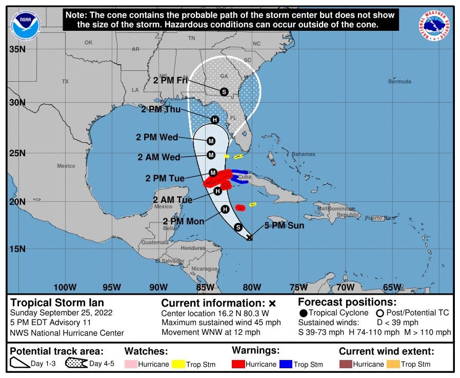
As of the 5 p.m. advisory Sunday from the hurricane center, Ian was a 45-mph tropical storm 495 miles southeast of the western tip of Cuba. It was moving west-northwest at 12 mph.
But Ian is forecast to be a major hurricane before making landfall in northwest Florida or the Panhandle, according to the National Weather Service. Martin, Indian River and St. Lucie counties appear to outside the "cone" of impact, according to the latest National Hurricane Center.
The exact path of the storm, and severity of the weather around it, is hard to predict, said Brandon Schaefer, a meteorologist with the National Weather Service in Melbourne.
"Right now the center of the storm is expected to stay in the eastern Gulf (of Mexico) through a good portion of the day on Thursday, before making landfall somewhere along the Big Bend of Florida," Schaefer said. "And that's the current forecast. But impacts and effects of the storm will be felt well away from its center."
Schaefer said high wind gusts and heavy rainfall may drench the Treasure Coast as an effect of the storm.
"So heavy rainfall is going to be a concern, especially with the amounts of rain we've seen the past few days," Schaefer said. "Anything on top of that is going to raise a concern for flooding."
Schaefer said the Treasure Coast has a 20-30% chance of tropical storm force winds hitting the area.
Despite forecasts showing the center of the storm swaying far away from the Treasure Coast, Waite, the emergency management director, said people need to stay prepared.
"So especially with the way the storm has been has been acting ... everyone should remain vigilant," Waite said. "That's that's my new word for this storm."
Waite advised to stock up on water, one gallon per person per day and to have at least a 7-day refill of medication. Emergency shelters will open in Martin County if needed, Waite said, and people should register any special needs they have on the county's website.
"They ... should be putting in their application now for that, for the rest of the hurricane season and even for next year," Waite said.
Some Treasure Coast residents were already loading their trunks with water and food Sunday for the hurricane.
Zack Valsaint, of Fort Pierce, loaded several packs of bottled water on the bed of his truck at the Port St. Lucie Walmart. He said he stocks up on food, canned goods and water before any storm.
"I like to prepare before anything," Valsaint said. "I don't want to be the last-minute shopper."
Mauricio La Plante is a breaking news reporter for TCPalm focusing on Martin County. Follow him on Twitter @mslaplantenews or email him at Mauricio.LaPlante@tcpalm.com.
This article originally appeared on Treasure Coast Newspapers: Treasure Coast officials urge preparation for Tropical Storm Ian

