NC’s salt marshes hold 64 million tons of carbon dioxide. What happens if they die?
On a recent weekend, a family went fishing feet away from a salt marsh in the northwest corner of Carolina Beach State Park, about 20 minutes south of downtown Wilmington.
They were likely unaware that the grass just a few feet away is a potential tool in the state’s fight against climate change, but one that could swiftly turn into a source of atmosphere-warming greenhouse gases as sea levels rise.
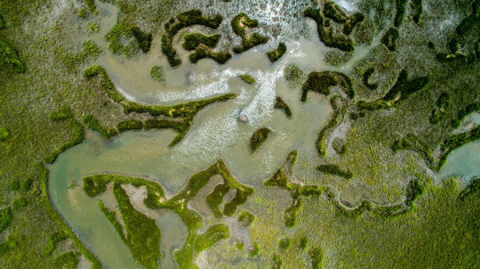
There are about 220,000 acres of salt marsh on the North Carolina coast, a collection of grasses that live in the muddy zone frequently washed over by tides.
Right now, those marshes are holding about 64 million tons of carbon dioxide, according to researchers from Duke University and the National Oceanic and Atmospheric Administration. Each year, North Carolina’s marshes capture the equivalent of an additional 250,000 metric tons of carbon dioxide — about as much greenhouse gas as 54,347 cars generate per year.
But as the world continues to warm and sea levels rise, salt marshes and seagrass are likely to drown or be washed away. As that happens, they will shift from being a tool in the fight against global warming, a so-called carbon sink, to their remains being a contributor to it, a source of carbon.
How salt marshes survive

When salt marshes are threatened by sea level rise, they have two survival strategies.

One is by increasing their elevation by trapping sediment or using below-ground biomass.

Another way is to move upland as sea level rises and salt water moves inland. The problem comes when bulkheads and other hard surfaces get in the way.
If sea levels rise 4 feet by 2100, researchers estimate that 134,000 acres of North Carolina’s salt marsh will be lost to drowning or erosion by 2053 and 194,000 acres by 2073, Duke University and NOAA researchers included in a draft version of North Carolina’s Coastal Habitat Protection Plan.
“In North Carolina, given expected sea level rise rates and current sedimentation rates and erosion rates, it looks like our salt marsh is not likely to be able to keep up,” said Lydia Olander, the director of the Ecosystem Services Program at Duke University’s Nicholas Institute for Environmental Policy Solutions.
In addition to the carbon impact, losing salt marshes would lead to the loss of habitat for juvenile fish and have a detrimental impact on water quality by leading to a decreased stormwater buffer.
How salt marshes make great blue carbon habitats
For millennia, salt marshes have kept pace with rising sea levels.
The slow-moving growth of salt marshes is powered in part by tides, which carry sediment and plant leaves toward the shore where they can settle on the salt marsh’s surface, Devon Eulie, a UNC-Wilmington professor of coastal processes and policy, wrote in an email.
Simultaneously, Eulie said, the plants that make up the salt marsh are growing, boosting the soil with their roots.
Because salt marshes work to keep up with sea level rise, the grasses are actually capable of increasing production in the face of danger, said Antonio Rodriguez, a coastal geologist at UNC-Chapel Hill’s Institute of Marine Sciences. They capture more carbon, photosynthesizing it and growing more.
“It’s intertidal and it builds soils relatively rapidly. That’s what makes it such a great blue carbon habitat,” Rodriguez said, referring to the process by which aquatic ecosystems capture and store the planet-warming greenhouse gas.
The fields of spiky grasses that make up salt marshes capture carbon from the atmosphere, photosynthesizing it and using it to boost themselves upwards, a millimeter-by-millimeter race to avoid being drowned by the encroaching sea. Marshes are generally capable of keeping up with slow-moving sea level rise, with the draft protection plan stating, “Coastal wetlands that can keep pace with sea level rise and not drown in place have a near limitless capacity to sequester carbon.”
But, Rodriguez said, “When sea level rises too rapidly and the salt marsh can’t keep up with that, then it reaches that tipping point. And then it’s very stressed and the biomass goes down and it starts to collapse.”
Once tides begin to chew away at the shoreline, Rodriguez added, they are washing older carbon out of the soil and into the open water where at least some of it is processed and ends up back in the atmosphere as carbon dioxide, a gas that plays a key function in heating the globe.
As sea level rise begins to threaten the marsh, Eulie wrote, the native cordgrasses and needlerushes could begin to die due to higher levels of saltwater flooding the marsh, potentially replaced by non-native grasses. The marsh will often begin to show signs of erosion, too, developing small cliffs on its edges.
“As the water gets deeper and floods the marsh more frequently, you have greater potential for that flow and any waves — from both wind and nearby vessel traffic — to physically erode the edge,” Eulie wrote, adding that erosion is location-specific and can be complicated by other factors like dredging and historic ditching and draining to control mosquitoes.
Sea level rise threatens salt marshes
South Atlantic salt marshes most threatened by rising sea levels are on the southern North Carolina coast, the Murrells Inlet and Charleston areas of South Carolina, and Jacksonville, Fla., according to resiliency maps from the National Oceanic and Atmospheric Administration. Threats also exist in the Hilton Head Island-Savannah area. Areas in red and orange on this map show spots where marshes are least resilient to sea level rise. Areas in green are most resilient. Source: NOAA
Are NC marshes keeping up with rising sea levels?
Salt marshes can add soil beneath them at a maximum of about 12 millimeters per year, or about 3 feet, 11.24 inches over a hundred-year period. But that is only under perfect conditions, and many parts of the North Carolina coast could see that much sea level rise by 2100, according to the state’s Climate Science Report.
As sea levels rise in the second half of this century, waves will erode the front edge of marshes and frequent inundation will begin to outpace marsh’s ability to add soil, said Katie Warnell, an Ecosystem Services Program policy associate. As saltwater creeps upward and inward, freshwater wetlands and forests will transition to salt marsh and then, in many cases, to open water.
If sea levels rise 2 feet, research indicates that tides pushing inland could actually lead to the creation of more salt marsh than exists right now. But at higher levels of sea rise, the amount of lost marsh quickly begins to outpace the creation of new marsh.
“There’s kind of this constant shift inward of salt marsh and then it starts to be lost as the water gets deeper in those areas,” Warnell said.
The disappearing marsh will not be the only contributor of greenhouse gases, with the dying forest also sending carbon into the atmosphere.
On the Albemarle-Pamlico Peninsula, about 15% of the forest changed into a ghost forest between 2001 and 2014, according to research from N.C. State University. The Albemarle-Pamlico Peninsula is a collection of rural Eastern North counties running from Beaufort in the west to mainland Dare County in the east, with the Albemarle Sound making up the northern border and the Pamlico Sound the southern border.
When saltwater begins to infiltrate a ghost forest, trees begin to shed their bark and eventually bleach as they die, many still standing.
From his oyster lease in Westmouth Bay off the northern edge of Harkers Island, Ryan Bethea is about a half-mile away from Browns Island, an uninhabited clump of marsh and forest that sits between Harkers Island and Marshallberg.
The southern half of the island is a collection of gray now, saltwater bleaching what was once a forest. The only green remaining is on the northern side.
“The pines and stuff can’t take the inundation of seawater so they essentially die,” Bethea said. “We see that stuff, that’s short-term. You can probably look at a picture (from) 15 years ago and see the difference.”
The Coastal Habitat Protection Plan says it is important to protect the low-lying areas where salt marshes are likely to shift as sea levels rise. By 2026, the plan says, the N.C. Department of Environmental Quality should work with local governments, nonprofits and scientists to conserve those corridors, protecting them from development.
Those efforts are, however, likely to come at a high price tag, said Braxton Davis, the director of North Carolina’s Division of Coastal Management.
“What we probably need is a coastwide plan in North Carolina that really drives our funding decisions,” Davis said, noting that such a document would help make the case for funding the purchase and protection of specific pathways.
Taking clean water and the environment for granted
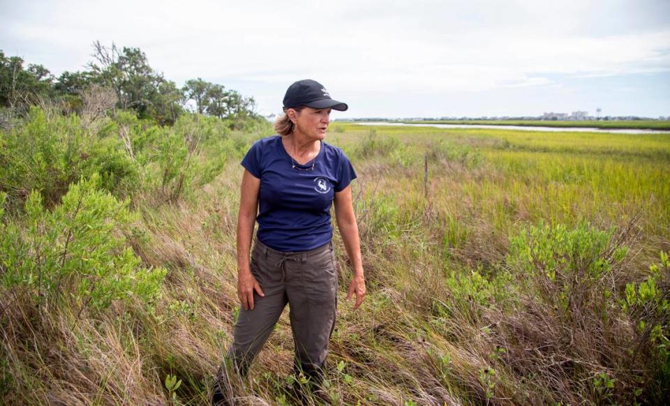
Tracy Skrabal, an N.C. Coastal Federation senior scientist, sits in a skiff docked in Lees Cut, on the backside of Wrightsville Beach. Skrabal is floating in a part of the waterway between two clutches of salt marsh, a vast field of green grass on one side and mudflats sloping gradually upward to marsh and then onto a grove of trees on the other.
Just out of sight on either side is rampant coastal development, indicated by docks that have been built across marshes and bulkheads. As Skrabal speaks, the sounds of hammer strikes echo across the waterway, a new house going up on the backside of Wrightsville, its shoreline already bulkheaded.
Where the middle of Lees Cut is a vibrant coastal ecosystem, the backside of Wrightsville Beach is mostly a barren collection of different-colored bulkheads and docks with a few strings of marsh grass still hanging on amid the boat wakes and rebounding waves.
“I think folks in my generation and the generation before me just took it for granted as we take for granted clean water and the environment in general. I think it’s only now that we’re waking up to the true effects of climate change, sea level rise,” Skrabal said. “We’re starting to look for solutions and we’re really realizing the incredible benefits that are provided to us, more or less free of charge by these coastal wetlands and the estuaries themselves.”
When saltwater begins destroying a marsh, Skrabal said, it will look like somebody dumped pollution on the ecosystem. This is happening in “splotches” up and down the North Carolina coast, often starting on the marsh edges but sometimes in the middle of marshes that sit at lower elevations.
Skrabal said, “We need to do everything we can to protect them, to allow them to continue to grow and keep pace with sea level rise.”
“If at some point we’re able to start reducing sea level rise and start to reach an equilibrium, the coastal system will also reach an equilibrium and will stop drowning all this habitat which means the system could switch back to being a carbon sink eventually,” Olander said. “It’s losing all these habitats that is making this a carbon source.”
Low, mid and high tides by McClatchy on Sketchfab
This story was produced with financial support from 1Earth Fund, in partnership with Journalism Funding Partners, as part of an independent journalism fellowship program. The N&O maintains full editorial control of the work.

