Live updates: EF1 tornado reported Wednesday in Outagamie County near Seymour
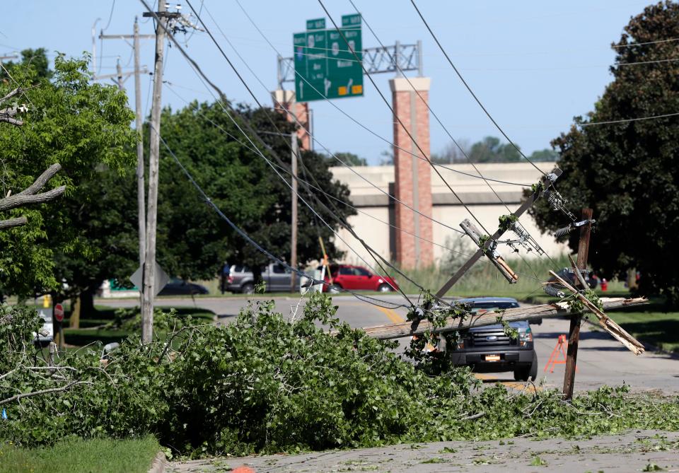
A severe weather outbreak tore across a large area of Wisconsin on Wednesday, including most or all of the state's largest population centers, including Milwaukee, Green Bay, Appleton, Oshkosh, Wausau, Madison and La Crosse.
Here's what's happening:
EF1 tornado reported near Seymour
An EF1 tornado was reported in the Outagamie County city of Seymour, according to a preliminary storm report from the National Weather Service in Green Bay. AN EF1 tornado was reported at 6:17 p.m. Wednesday.
The weather service's Enhance Fujita scale defines an EF1 tornado as having wind gusts of 86-110 mph.
(1230 PM) One of our storm survey teams just reported a EF1 tornado in the city of Seymour in Outagamie county. Will be updating more information thru the afternoon. pic.twitter.com/KYpgRNXxJv
— NWS Green Bay (@NWSGreenBay) June 16, 2022
— Pete Frank
It could take several hours to restore power in Green Bay area
Some Wisconsin Public Service customers in the Green Bay and Fox Valley may be without power for a couple of days, the utility said.
Wednesday night's storms knocked out power to nearly 160,000 WPS customers, and northeastern Wisconsin was the hardest hit, WPS said. "Customers in those areas" should be prepared for a multi-day restoration effort," WPS said.
WPS and We Energies have received more than 1,000 reports of downed trees, snapped power lines and poles.
WPS urged people to stay at least 25 feet away from any downed wires.
— Pete Frank
Lightning likely caused two house fires in Washington County
Fire departments from throughout Washington County battled two house fires believed to have been caused by lightning strikes Wednesday night as severe storms moved through the area.
Both fires scenes were about 35 miles northwest of Milwaukee.
The first fire was reported at 8:45 p.m. in the 5400 block of Hideaway Circle in the Town of Wayne, said Sgt. Alexander Herriges of the Washington County Sheriff’s Office, in a statement.
A caller reported that there was a fire in the attached garage of the residence and that flames were coming from the roof.
The first Kohlsville Fire Department firefighters on the scene reported fire and heavy smoke coming from the roof, according to dispatch audio from Broadcastify.
Fire departments from Allenton, Slinger, Kewaskum, Campbellsport, West Bend, and St Lawrence battled the fire.
There were no injuries and the fire caused at least $175,000 in damage, Herriges said.
The cause of the fire is “believed to be the result of a lightning strike to the roof of the residence,” Herriges said.
Then, at 10:24 p.m., firefighters and sheriff’s deputies were called to a house fire in the 3400 block of Town Line Road in the Town of Polk.
A 911 caller told dispatchers that she believed there was a fire in the ceiling of the house.
“They believe the house was hit by lightning. There is black smoke and the smoke detectors are alarming,” a dispatcher radioed to responding sheriff’s deputies and firefighters.
“There are flames visible on the roof and it is spreading very quickly,” the first sheriff’s deputy on the scene radioed to dispatchers.
The Jackson Fire Department responded and immediately called for mutual aid. Emergency crews from Hartford, Slinger, Kewaskum, Cedarburg, West Bend, Fillmore, Newburg, Richfield, St. Lawrence and Germantown, as well as a Lifestar Rescue ambulance responded to the scene.
The fire caused at least $150,000 in damage, Herriges said, and no injuries were reported. The American Red Cross is assisting the family that lived at the home.
— Joe Taschler
Rainfall totals indicate Watertown got nearly 6 inches of rain
Storms across Wisconsin on Wednesday brought several inches of rain, and flooding, to some communities.
Rainfall totals indicate Watertown saw nearly 6 inches of rain while Milwaukee was under an inch and Waukesha got 1.21 inches. Here's a look at area rainfall totals:
Watertown: 5.9"
Lake Mills: 3.9"
Jackson: 3.04"
West Bend: 2.34"
Allenton: 2.2"
Campbellsport: 2.17"
Plymouth: 1.81"
Cedarburg: 1.59"
Pleasant Prairie: 1.36"
Waukesha: 1.21"
Germantown: 1.21"
Milwaukee: 0.71"
— Steven Martinez
Nearly 50,000 customers are still without power in Wisconsin
About 50,000 customers across Wisconsin did not have power as of 8:10 a.m. Thursday following two days of storms.
We Energies reported 37,603 customers without power in southeast Wisconsin. There were 11,737 Alliant Energy customers without power mostly in central Wisconsin and in and around Sheboygan County.
On Wednesday, storms rocked the state for hours, downing trees and powerlines. Tornado touchdowns were reported near Tomah and Mauston, according to the National Weather Service.
— Steven Martinez
Nearly 90,000 customers without power across the state
As of 10:30 p.m., outage maps for utilities groups show that nearly 90,000 people are without power in Wisconsin. We Energies reports at least 63,000 customers are without power, at least 27,000 are without power in the southeastern part of the state.
Alliant Energy reports at least 13,000 customers without power, with the most severely affected area being central part of the state. And, the Wisconsin Electric Cooperative Association reports at least 12,000 customers are without power as a result of tonight's storms.
— Drake Bentley
Explanation of why tornado watch is extended until 1 a.m.
The storms are still not finished making their way through the far southeast portion of Wisconsin, including the Milwaukee metro area.
While storms have diminished in intensity from what was occurring across Wisconsin on Wednesday afternoon, there is still enough energy in the atmosphere to generate additional severe weather in the southeast, said Sarah Marquardt, a meteorologist with the National Weather Service in Sullivan.
So, forecasters decided to extend the tornado watch until 1 a.m.
“The chance (for severe storms) is not as high as it was earlier today, but there is still a small chance,” Marquardt said. “The line of thunderstorms is expected to slowly move across (southeast Wisconsin) during the next few hours and bring lightning and heavy rain and a small chance for a severe thunderstorm or a tornado.”
The storms are continuing to feed off warm, humid air. At 10 p.m. at Milwaukee Mitchell International Airport it was still a muggy 80 degrees.
The thunderstorms are “still holding on enough that we are still watching them for severe potential,” Marquardt said.
-- Joe Taschler
Many roads impassable in Brown, Outagamie counties
Emergency government in both counties warned drivers about possible road closures following the storm. Downed trees and power lines along with debris on roadway will continue to block roads for the next couple of days, Brown County Emergency Management said in an alert. Outagamie County said many roads are impassable because of storm damage.
Tornado watch extended for southeastern Wisconsin until 1 a.m.
The National Weather Service has extended the tornado watch until 1 a.m. Thursday for southeastern Wisconsin and parts of central Wisconsin.
The watch includes 10 counties: Sheboygan, Rock, Jefferson, Kenosha, Milwaukee, Ozaukee, Racine, Walworth, Washington and Waukesha.
--Drake Bentley
9:20 p.m.: Severe thunderstorm warning for Ozaukee and southeastern Washington counties
The National Weather Service has issued a severe thunderstorm warning for Ozaukee County and southeastern Washington County until 10 p.m. This area includes Grafton, Cedarburg and Richfield. The NWS said in a statement that wind gusts are up to 60 mph.
Flash flood warnings issued for southern Wisconsin
The National Weather Service in Sullivan has issued a flash flood warning for portions of Waukesha, Washington, Ozaukee, Sheboygan, Fond du Lac, Dane, Rock, Dodge and Jefferson counties.
"At 8:46 p.m., Doppler radar indicated thunderstorms producing heavy rain across the warned area. Between 1 and 1.5 inches of rain have fallen. The expected rainfall rate is 1 to 2 inches in one hour. Additional rainfall amounts of 1 to 3 inches are possible in the warned area," according to a statement from the weather service.
-- Joe Taschler
Number of customers without power grows to 70,000 in Wisconsin
The number of power outages across Wisconsin was at least 70,000 as of 7:45 p.m. We Energies was reporting nearly 43,500 customers without power, most of them in the state's Fox Valley region.
Alliant Energy is reporting about 15,000 customers are without power, primarily in its central Wisconsin service territory.
Cooperative utilities in the state were also reporting more than 15,000 customers without power as a result of storms, according to the Wisconsin Electric Cooperative Association.
--Joe Taschler
7:31 p.m.: Green Bay police and fire department ask people to avoid traveling through city

As the Green Bay Police and Green Bay Metro Fire Department deal with storm damage including downed trees and power lines, street flooding and power outages across the city, the departments asked people in a statement to avoid traveling through the city “unless absolutely necessary.”
Multiple accidents with injuries have occurred due to power outages that left traffic lights out. For people that have to travel while a traffic light is out, the departments reminded people to treat each intersection like a four-way stop, allowing each direction to take turns.
The departments also warned people not to approach downed power lines.
People are asked to continue to report storm damage to non-emergency police number at 920-391-7450 and police numbers to 911. Wisconsin Public Service can be contacted for assistance with electricity and power lines.
— Kelli Arseneau
7:39 p.m.: No tornado warnings in effect; watch continues
For the first time in several hours, as of 7:30 p.m., there were no tornado warnings in effect anywhere in Wisconsin.
A line of strong to severe thunderstorms continued to approach the Milwaukee area and with their history of producing tornadoes across the state, residents in the Milwaukee metro area should not let their guard down just yet, according to the National Weather Service.
A severe thunderstorm warning remains in effect until 8 p.m. for northern Jefferson and Dodge counties.
"At 7:15 p.m., severe thunderstorms were located along a line extending from Columbus to Waterloo, moving northeast at 55 mph," the weather service said in a statement.
A tornado watch remains in effect until 10 p.m. for southern Wisconsin, including the Milwaukee metro area.
-- Joe Taschler
7:37 p.m.: Storm delays WIAA baseball games in Appleton
Shortly after the Division 3 state baseball semifinal matchup between St. Croix Falls and Kenosha St. Joseph, the tornado sirens sounded and Fox Cities Stadium workers moved rapidly to get everybody into safe surroundings. Right after the game, many of the Kenosha contingency that made the trip were escorted underneath the stadium while the storm passed through. It provided some tight quarters for everybody, but fans, parents, players and coaches were all safe and checking their phones to see what was coming.
🚨 STATE BASEBALL WEATHER POSTPONMENTS 🚨
D2 Semifinals are postponed to Thursday, June 16 at Nienhaus Field in Appleton.
8 am: #1 Mosinee vs. #4 Jefferson
Approx. 10:30 am: #2 Pewaukee vs. #3 Denmark
Stay tuned to WIAA social media or https://t.co/Utvs44blFk for updates. pic.twitter.com/nwk0HCTA6l— WIAA State Tournaments (@wiaawistate) June 16, 2022
Players, parents and fans hunkered down for about 20 minutes or so before people were allowed to leave the stadium. The rain has picked up and slowed down for a couple hours, with thunder and lightning throughout. The final two games in the WIAA baseball playoffs have been postponed until Thursday.
— Michael Whitlow
7:23 p.m.: The Milwaukee Night Market is shut down for the evening
Due to incoming thunderstorms and rain for the Milwaukee area, including downtown, organizers have decided to shut down the Milwaukee Night Market at 7 p.m.
Update from @mkenightmarket:
"Due to inclement weather and for the safety of guests and vendors, tonight’s Milwaukee #NightMarket will shut down at 7pm. Please stay safe tonight!" https://t.co/TIZ9VYocmL— MilwaukeeDCD (@MilwaukeeDCD) June 16, 2022
Over 100 vendors signed up to be part of this season's inaugural night market. Hundreds were expected to travel downtown near West Wisconsin Avenue between 2nd Street & Vel R. Phillips Avenue.
The event returns on July 13.
— Drake Bentley
7:20 p.m. Power outages continue across Wisconsin
More than 47,700 Wisconsin Public Service customers are without power across Wisconsin. 28,800 of those are in Brown County.
7:12 p.m.: Storms holding together as they move east
At 7 p.m., a line of severe thunderstorms stretched from Marinette, which is north of Green Bay, through Madison and south into Illinois.
The storms are holding together as they march east across the state and forecasters expect they will hold together as they approach the Milwaukee metro area.
The storms are moving into an environment of warm, humid, unstable air.
The severe storms have a history of producing tornadoes and damaging straight-line winds.
Damage from the storms has been reported throughout western, central and northeast Wisconsin and thousands are without power.
— Joe Taschler
7:02 p.m.: Worst moves out of Brown County
The National Weather Service reports via the Brown County Sheriff's Office that the worst of the storm has passed the county. A few weaker storms will still be on the way.
7 p.m.: A line of severe thunderstorms stretch from Marinette to Madison and south into Illinois
The storms are holding together as they march east across the state and forecasters expect they will hold together as they approach the Milwaukee metro area.
The storms are moving into an environment of warm, humid, unstable air.
The severe storms have a history of producing tornadoes and damaging straight-line winds.
Damage from the storms has been reported throughout western, central and northeast Wisconsin and thousands are without power.
— Joe Taschler
6:55 p.m.: Tornado warning for Sun Prairie, Beaver Dam and Columbus
The National Weather Service has issued a tornado warning for Sun Prairie, Beaver Dam and Columbus until 7:30 p.m.
@ryanhallyall we’ve got greenish clouds that seem to be rotating in Sun Prairie, WI. #wiwx pic.twitter.com/HsaUDu6yK8
— Dustin Weber (@dj2emt) June 15, 2022
6:55 p.m.: Storm impacts traffic in Green Bay and Howard
Three eastbound lanes are closed on State 172 at Ashland, due to a semi truck that tipped over from strong winds, the Brown County Sheriff’s Office said in a tweet around 6:34 p.m.
Additionally, in a tweet at 6:37 p.m., sheriff’s office warned drivers to avoid Velp Avenue in Howard, where downed power lines have made the road impassable.
6:40 p.m.: Tornado warning for Marinette, Oconto and Peshigo
The National Weather Service has issued a tornado warning until 7:15 p.m. for an area that includes Oconto, Abrams, Peshtigo and Marinette.
At least 35,000 without power across Wisconsin
Milwaukee-based We Energies says it has nearly 16,000 customers without power across its service territory, including 10,000 customers out of power in the Fox Valley.
Alliant Energy says nearly 22,000 customers in its central and southwest Wisconsin service territory were without power as of 6:08 p.m. as a result of severe storms that have moved across the state.
6:21 p.m.: Tornado warnings for Brown and Outagamie counties
The National Weather Service in Green Bay issued tornado warnings for northern Brown and northeastern Outagamie counties in effect until 6:45 p.m.
6:20 p.m.: Businesses damaged in Mauston after strong winds; Power lines, trees down
More damage from here in Mauston, WI #wiwx @NWSLaCrosse @CBSNews pic.twitter.com/wrxKq0KIYC
— Ryan Knapp (@ryantknappwx) June 15, 2022
Power lines and trees were downed during strong thunderstorms in Mauston, according to city administrator Randy Reeg.
Car windows and glass doors to businesses were shattered, and roofs were damaged on some local hotels and restaurants, according to Reeg and social media posts. Street signs were also toppled.
Reeg did not have much information about initial reports that the Mauston hospital was damaged, but he said the electricity there was out. The hospital was inaccessible by road for a time because of downed power lines.
Reeg did not have any reports of injuries or deaths in Mauston.
Winds were strong enough to overturn semi-trucks, posts on social media showed.
Photos posted to social media showed a row of large pines outside the hospital, their top halves sheared off. Debris littered the parking lot.
The National Weather Service tweeted about 4:45 p.m. that a tornado was moving toward Mauston.
“There is most definitely tornado damage here in Mauston,” the city of Mauston posted on its Facebook page.
The Facebook post urged residents not to go out and survey the damage right now.
“While human nature might urge you to go check out the damage, PLEASE STAY HOME! There are trees and power lines down, along with debris littered about. Don't risk an injury, and don't inhibit the ability of our first responders to do their job! Stay safe!” the post reads.
— Sophie Carson
6:18 p.m: Tornado warnings for Oconto, Oconto Falls and Bonduel
As the storms move into Shawano and Oconto counties an area that includes Oconto, Oconto Falls and Bonduel has been put under a tornado warning until 6:45 p.m. Penny-size hail is possible, according to the National Weather Service.
6:08 p.m.: Tornado warnings for Waupaca, Outagamie and Shawano
The national National Weather Service Green Bay has issued a tornado warning for northeastern Waupaca County, northwestern Outagamie County and central Shawano Counties until 6:30 p.m.
6 p.m: Tornado warnings for New London, Seymour, Hortonville, Manawa, Bear Creek, Nichols
A line of storms continue to move its way east with tornado warnings issued for New London, Seymour and Hortonville until 6:15 p.m. The National Weather Service in Green Bay says wind gusts in the thunderstorms will reach 80 mph. The tornado warning runs for Manawa, Bear Creek and Nichols until 6:30 p.m.
Line of storms with embedded tornadoes racing across Wisconsin
At 5:45 p.m, a line of strong to severe storms extended from northeast of Wausau southwest to the Iowa/Wisconsin border, according to National Weather Service radar.
That line of storms is continuing to race east and is expected to hold together as it moves into an area of hot, humid unstable air in place across eastern Wisconsin.
“Numerous severe thunderstorms with embedded tornadoes are occurring along that line as it moves across the state,” said Sarah Marquardt, a National Weather Service meteorologist in Sullivan. “There have been several tornadoes and very strong straight-line winds also.
“We’re estimating winds with some of these storms are 60 to 80 mph,” she added. “Those are very, very strong straight-line winds.”
Images of storm damage from western and central Wisconsin have been posted on social media.
Marquardt said forecasters expect the storms to hold together as they approach eastern Wisconsin.
“Right now we’re watching central Wisconsin where there are numerous tornado warnings,” she said. “That line of storms is going to continue moving east through this evening.
“Everyone in eastern Wisconsin should pay attention to the weather and be prepared to take shelter as these storms approach,” Marquardt said.
A tornado watch remains in effect across all of central and eastern Wisconsin, including the Milwaukee metro area, until 10 p.m.
At 5:45 p.m., the temperature at Milwaukee Mitchell International was a soupy 95 degrees.
“That warm humid air across southern Wisconsin and the way the winds are, it’s a very favorable environment for severe weather,” Marquardt said. “We’re expecting the line of storms to continue to move east.
“Be weather aware and ready to take cover as storms approach,” she added.
— Joe Taschler
5:43 p.m.: Tornado warning for Neopit, Mattoon and Bowler
The National Weather Service in Green Bay has issued a tornado warning for an area spanning Shawano and Menominee counties that includes Neopit, Mattoon and Bowler until 6 p.m.
5:36 p.m.: Tornado warning for Antigo, Deerbrook and Bryant
The National Weather Service in Green Bay has issued a tornado warning for an area that includes Antigo, Deerbrook and Bryant until 6 p.m.
5:23 p.m.: Tornado warning for Wautoma, Redgranite, Coloma
The National Weather Service in Green Bay has issued a tornado warning for an area that includes Wautoma, Redgranite and Coloma until 5:45 p.m.
5:10 p.m.: Tornado warning for Stevens Point, Wisconsin Rapids, Wausau area
A tornado warning was issued about 5 p.m. for parts of Wood, Portage and Marathon counties until 5:30 p.m., according to the National Weather Service in Green Bay.
The warning includes Stevens Point, Wisconsin Rapids, Plover, Wausau, Weston and Rothschild.
4:59 p.m.: Tornado warning for Wisconsin Dells, Lake Delton area
Numerous tornado warnings are in effect in Wisconsin, including a tornado Warning for northwestern Sauk County until 5:30 p.m.
At 4:48 p.m., a severe thunderstorm capable of producing a tornado was located 10 miles northeast of Richland Center, moving northeast at 55 mph," according to the National Weather Service. "Locations impacted include Reedsburg, Wisconsin Dells, Lake Delton, La Valle, Ironton and Lime Ridge.
— Joe Taschler
4:43 p.m.: Tornado warning for parts of Juneau, Adams counties
Flipped trailers and lots of poles down in Mauston. Some roofs blown over. It does seem to be in a narrow line across town WSW to ENE. #wiwx @NWSLaCrosse pic.twitter.com/pxg1KTTglV
— Sean Macaday 🇺🇦 (@MacadayWX) June 15, 2022
A tornado warning remains in effect until 5 p.m. for northwestern Juneau and northwestern Adams counties.
"At 4:29 p.m., a confirmed large and extremely dangerous tornado was located 10 miles northwest of Necedah, or 14 miles northeast of Tomah, moving northeast at 30 mph," according to the National Weather Service in La Crosse. "Damaging tornado continues. Radar indicates a continued stream of debris lofted into the air from the tornado."
People in areas covered by the warning are in "a life-threatening situation," the weather service said.
— Joe Taschler
4:28 p.m.: Tornado warnings across western, central Wisconsin
Numerous tornado warnings were in effect across western and central Wisconsin just before 4:30 p.m., according to the National Weather Service.
At 4:22 p.m., NWS confirmed a large and extremely dangerous tornado 11 miles northeast of Tomah, moving northeast at 40 mph.
“This is a particularly dangerous situation,” according to the weather service office in La Crosse. “Take cover now!”
— Joe Taschler
4:03pm likely tornado in progress Tomah WI @NWSLaCrosse pic.twitter.com/0xuKTsuREW
— Trey Greenwood (@StormChaseAZ) June 15, 2022
4:10 p.m.: Tornado reported near Tomah
A tornado warning is in effect until 5 p.m. for Juneau, Adams and Monroe counties.
"At 4:02 p.m., a confirmed tornado was located near Tomah, moving northeast at 40 mph," according to a statement from the National Weather Service in La Crosse. "The tornado will be near Necedah around 4:30 p.m.," according to the statement.
The weather service said the tornado has been confirmed by radar and weather spotter.
— Joe Taschler
2:35 p.m.: Tornado watch issued; includes Milwaukee metro area, Green Bay, Wausau, La Crosse
The National Weather Service has issued a tornado watch for a large portion of central and southern Wisconsin until 10 p.m.
Some of the cities covered by the tornado watch include Milwaukee, Waukesha, Appleton, Oshkosh, Green Bay, Sheboygan, Fond du Lac, Madison, Wausau, Wisconsin Rapids, Stevens Point, Marshfield, Manitowoc, Janesville, La Crosse, Wisconsin Dells, Sturgeon Bay and Rhinelander. It also encompasses the following counties:
Adams, Brown, Calumet, Clark, Columbia, Crawford, Dane, Dodge, Door, Florence, Fond du Lafc, Forest, Grant, Green, Green Lake, Iowa, Jackson, Jefferson, Juneau, Kewaunee, LaFayette, Langlade, La Cross, Lincoln, Manitowoc, Marathon, Marinette, Marquette, Menominee, Milwaukee, Monroe, Oconto, Oneida, Outagamie, Ozaukee, Portage, Richland, Rock, Sauk, Shawano, Sheboygan, Taylor, Trempeleau, Vernon, Vilas, Washington, Waukesha, Waupaca, Waushara, Winnebago and Wood.
— Joe Taschler

2:45 p.m.: The difference between a tornado watch and a tornado warning
A tornado watch defines a cluster of counties where tornadoes and other kinds of severe weather are possible in the next several hours. It does not mean tornadoes are imminent, just that you need to be alert, and to be prepared to go to safe shelter if tornadoes do happen or a warning is issued.
A tornado warning means that a tornado has been spotted, or that National Weather Service Doppler radar has detected a thunderstorm circulation which can spawn a tornado. “When a tornado warning is issued for your town or county, take immediate safety precautions,” according to the Storm Prediction Center.
— Joe Taschler

2:13 p.m.: Potential storm timing for southern Wisconsin
Forecasters expect severe storms to occur during the mid- to late-afternoon hours and continue into the evening. Storms are expected to move west-to-east across the region. Storms could weaken by the time they reach Milwaukee, "but no one in Milwaukee should let their guard down," said Mark Gehring, a National Weather Service meteorologist.
Here's a look at how forecasters expect the storms to evolve. The radar images are simulated.
— Joe Taschler
1:39 p.m.: Heat advisory remains in effect for Milwaukee area, Sheboygan, Fond du Lac
A heat advisory remains in effect until 8 p.m. on Wednesday for Fond du Lac, Sheboygan, Dodge, Washington, Ozaukee, Iowa, Dane, Jefferson, Waukesha, Milwaukee, Lafayette, Green, Rock, Walworth, Racine and Kenosha counties.
Heat index values — what the combination of temperature and humidity makes it feel like outside — are expected to reach as high as 102 degrees on Wednesday in those counties.
— Joe Taschler
1:31 p.m.: Two 'probable' heat-related deaths in Milwaukee
The Milwaukee County Medical Examiner’s Office is investigating two “probable” cases of heat-related deaths Wednesday.
Brian Peterson, the chief medical examiner, said the victims are a 39-year-old Milwaukee female and an 89-year-old Greenfield male. Both were pronounced dead Wednesday morning, according to the office’s online records.
Autopsies are scheduled for Thursday, Peterson said.
Milwaukee County and much of southeastern Wisconsin is under a heat advisory until 8 p.m. Wednesday, according to the National Weather Service in Milwaukee. Heat index values are expected to reach as high as 102 degrees.
— Elliot Hughes
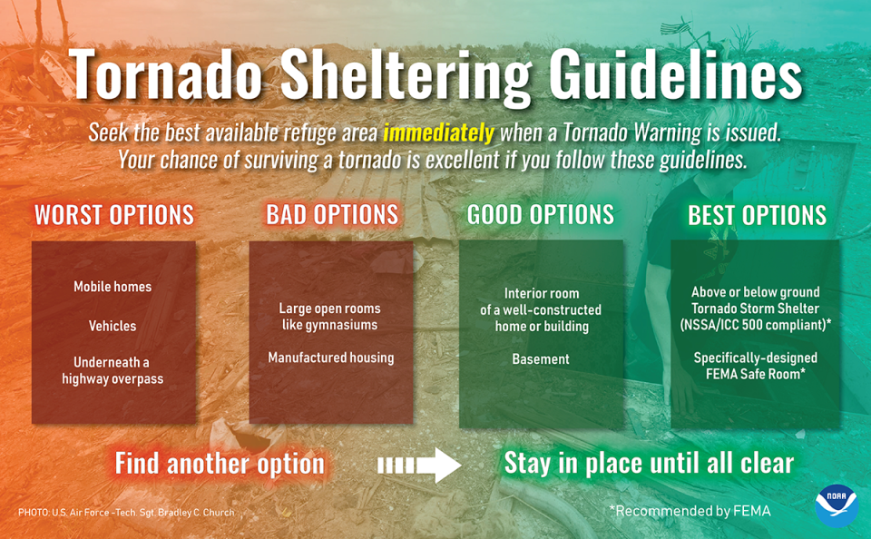
1:26 p.m.: Campers need to be alert
Forecasters are urging anyone who is camping anywhere in Wisconsin on Wednesday to have a plan to seek shelter if severe storms approach.
Tents and campers provide very little protection against severe thunderstorm winds and tornadoes, weather service forecasters said.
Here are some recommendations for seeking shelter should the need arise.
— Joe Taschler
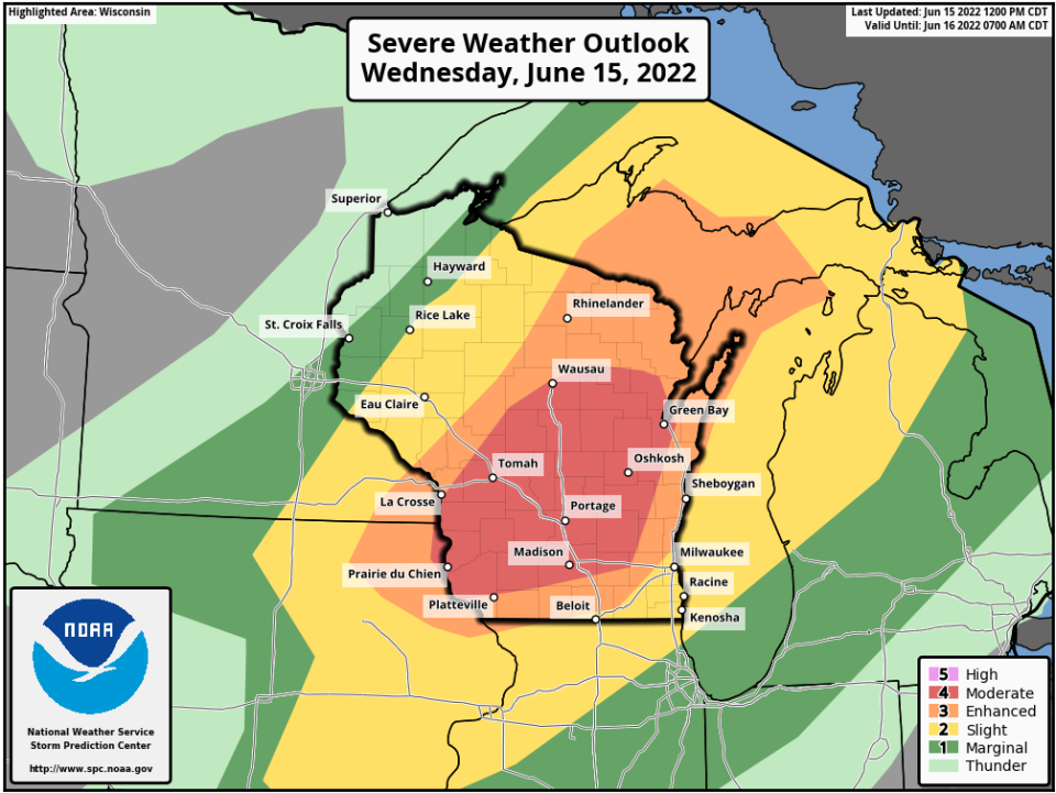
12:17 p.m.: Storm center upgrades risk for Wisconsin
The national Storm Prediction Center has placed a large portion of the state in a moderate — level 4 out of 5 — risk for severe storms.
While not necessarily rare, such a risk level is uncommon for Wisconsin, said Ben Miller, a meteorologist with the National Weather Service in Sullivan.
Almost the entire state on either side of a diagonal line from La Crosse to Green Bay is under a risk for severe storms, according to the Storm Prediction Center.
Here's where forecasters think the worst of the storms will occur:
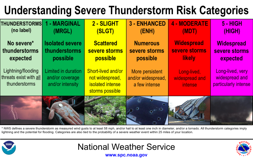
Here's how those risk areas are categorized:
A look at weather radars


This article originally appeared on Milwaukee Journal Sentinel: EF1 tornado reported Wednesday in Outagamie County near Seymour

